place

Grub Street

English phrasesHistory of literatureStreets in the City of LondonUse British English from June 2017
GrubStreet London 300dpi

Until the early 19th century, Grub Street was a street close to London's impoverished Moorfields district that ran from Fore Street east of St Giles-without-Cripplegate north to Chiswell Street. It was pierced along its length with narrow entrances to alleys and courts, many of which retained the names of early signboards. Its bohemian society was set amidst the impoverished neighbourhood's low-rent dosshouses, brothels and coffeehouses. Famous for its concentration of impoverished "hack writers", aspiring poets, and low-end publishers and booksellers, Grub Street existed on the margins of London's journalistic and literary scene. According to Samuel Johnson's Dictionary, the term was "originally the name of a street... much inhabited by writers of small histories, dictionaries, and temporary poems, whence any mean production is called grubstreet". Johnson himself had lived and worked on Grub Street early in his career. The contemporary image of Grub Street was popularised by Alexander Pope in his Dunciad. The street was later renamed Milton Street, which was partly swallowed up by the Barbican Estate development, but still survives in part. The street name no longer exists, but Grub Street has since become a pejorative term for impoverished hack writers and writings of low literary value.

Excerpt from the Wikipedia article Grub Street (License: CC BY-SA 3.0, Authors, Images).

Grub Street
Chiswell Street, City of London

Geographical coordinates (GPS) Address Nearby Places
placeShow on map

Wikipedia: Grub StreetContinue reading on Wikipedia

Geographical coordinates (GPS)

Latitude Longitude
N 51.520277777778 ° E -0.090833333333333 °
placeShow on map

Address

The Brewery & The Montcalm London City

Chiswell Street 52
EC1Y 4SA City of London (London Borough of Islington)
England, United Kingdom
mapOpen on Google Maps

GrubStreet London 300dpi
Share experience

Nearby Places

Citypoint
Citypoint

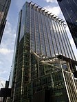
Citypoint (previously known as Britannic House and Britannic Tower) is a building located on Ropemaker Street on the northern fringe of the City of London, the main financial district and historic nucleus of London. Originally named Britannic House, Citypoint was built in 1967 as a 35-storey, 122-metre (400 ft) tall headquarters for British Petroleum (now BP), becoming the first building in the City of London area to exceed the height of St Paul's Cathedral. The designers were F. Milton Cashmore and H. N. W. Grosvenor. In 1991 British Petroleum moved back to their original headquarters on Finsbury Circus and the building was renamed Britannic Tower. It was refurbished in 2000, with additional floor space and the height increased to 127 metres (417 ft). The designer for the refurbishment was Sheppard Robson. It was renamed Citypoint after its refurbishment. Citypoint is the 11th-tallest building in the City and the 57th-tallest in Greater London. In August 2005 its owner, Pillar Properties, sold the building for more than £500 million in one of the largest deals ever seen in the City office market. In early 2007 the building was again put on the market, this time for £650 million, and purchased by Beacon Capital Partners, a private American company. At the time it was the most expensive building sale in the United Kingdom. A few months later, the sale of 8 Canada Square at Canary Wharf eclipsed this when it was sold for over £1 billion. A number of other large buildings have been constructed nearby, including The Heron, a 36-storey 112-metre (367 ft) residential tower at Milton Court and a 90-metre (295 ft) office tower at Ropemaker Place developed by British Land.