Tapu, New Zealand
Populated places around the Firth of ThamesPopulated places in WaikatoThames-Coromandel DistrictUse New Zealand English from July 2019

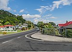
Tapu is a locality on the western side of the Coromandel Peninsula of New Zealand. State Highway 25 runs through it. Coromandel is 35 km to the north, and Thames is 19 km to the south. The Tapu River flows from the Coromandel Range past the settlement and into the Firth of Thames to the west. The "Tapu-Coroglen Road", a windy gravel road, connects it across the Coromandel Range with Coroglen in the east. The Square Kauri is on this road.
Excerpt from the Wikipedia article Tapu, New Zealand (License: CC BY-SA 3.0, Authors, Images).Tapu, New Zealand
Thames Coast Road,
Geographical coordinates (GPS) Address Nearby Places Show on map
 Continue reading on Wikipedia
 Geographical coordinates (GPS)
| Latitude | Longitude |
|---|---|
| N -36.983333333333 ° | E 175.50166666667 ° |
Address
Thames Coast Road 780
3575
Waikato, New Zealand
Open on Google Maps