Josefstadt

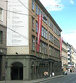
Josefstadt (German pronunciation: [ˈjoːzɛfˌʃtat] (listen); Central Bavarian: Josefstod) is the eighth district of Vienna (German: 8. Bezirk, Josefstadt). It is near the center of Vienna and was established as a district in 1850, but borders changed later. Josefstadt is a heavily populated urban area with many workers and residential homes. It has a population of 24,279 people (2014). With an area of 1.08 km² (.42 sq.mi.), Josefstadt is the smallest district in Vienna, and was named after the Holy Roman Emperor Joseph I. It consists of the former Vorstädte of Josefstadt, Breitenfeld, Strozzigrund, and Alt-Lerchenfeld, as well as parts of St. Ulrich and Alservorstadt. The district borders are formed by Alser Straße (north), Lerchenfelderstraße (south), Hernalsergürtel and Lerchenfeldergürtel in the west, and Auerspergstraße and Landesgerichtsstraße in the east. Josefstadt has developed into a middle-class neighbourhood. Most mayors of Vienna have lived here, as does Austria's former president. Due to its proximity to the University of Vienna, Josefstadt is also the home of many students. On the basis of the 2005 municipal elections, Josefstadt became Vienna's second district ever (after Neubau) to have a Green district director.
Excerpt from the Wikipedia article Josefstadt (License: CC BY-SA 3.0, Authors, Images).Josefstadt
Fuhrmannsgasse, Vienna Strozzigrund (Josefstadt)
Geographical coordinates (GPS) Address Nearby Places Show on map
Geographical coordinates (GPS)
| Latitude | Longitude |
|---|---|
| N 48.210833333333 ° | E 16.348055555556 ° |
Address
Fuhrmannsgasse
Fuhrmannsgasse
1080 Vienna, Strozzigrund (Josefstadt)
Austria
Open on Google Maps


