place

Unterstrass

Canton of Zürich geography stubsDistrict 6 of ZürichFormer municipalities of the canton of Zürich
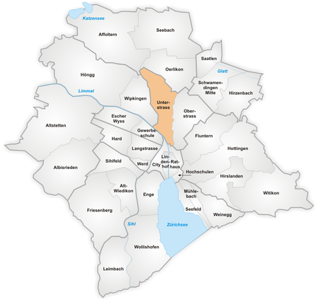
Karte Quartier Unterstrass

Unterstrass is a quarter in the district 6 in Zürich. It was formerly a municipality of its own, having been incorporated into Zürich in 1893. The quarter has a population of 19,921, in an area of 2.46 km2 (0.95 sq mi). In 1962, the faculty of science of the University of Zürich proposed to establish the Irchelpark campus on the Strickhofareal. The first stage the construction of the university buildings was begun in 1973, and the campus was inaugurated in 1979. The construction of the second stage lasted from 1978 to 1983. The campus also houses the anthropological museum Anthropologisches Museum, and the cantonal Staatsarchiv Zürich. Built in 1901 as Rigiblick restaurant, the former Gastsaal was re-opened as Theater Rigiblick in 1984.

Excerpt from the Wikipedia article Unterstrass (License: CC BY-SA 3.0, Authors, Images).

Unterstrass
Hofwiesenstrasse, Zurich Unterstrass

Geographical coordinates (GPS) Address Nearby Places
placeShow on map

Wikipedia: UnterstrassContinue reading on Wikipedia

Geographical coordinates (GPS)

Latitude Longitude
N 47.391446 ° E 8.53877 °
placeShow on map

Address

Hofwiesenstrasse

Hofwiesenstrasse
8042 Zurich, Unterstrass
Zurich, Switzerland
mapOpen on Google Maps

Karte Quartier Unterstrass
Share experience

Nearby Places

Weinberg Tunnel
Weinberg Tunnel

The Weinberg Tunnel (German: Weinbergtunnel) is a railway tunnel in the Swiss city of Zürich. The tunnel runs from the western approaches to Zürich Hauptbahnhof railway station, east under the station and city centre before turning north and surfacing on the southern approach to Zürich Oerlikon railway station, and allows trains running between east and west to pass through Zürich without reversal. It includes a new set of underground platforms at Zürich Hauptbahnhof, and carries twin standard gauge (1,435 mm or 4 ft 8+1⁄2 in) tracks electrified at 15 kV AC 16 2/3 Hz using overhead catenary.The tunnel was opened on 14 June 2014, and forms part of the Altstetten–Zürich–Oerlikon cross-city line, also known as the Durchmesserlinie Zürich, which also includes new elevated approach tracks from Altstetten to Zürich Hauptbahnhof, and the rebuilding of Oerlikon station with two additional tracks and platforms. At Zürich Hauptbahnhof, the tunnel serves a pair of underground island platforms, with four platform tracks, numbered as Hauptbahnhof tracks 31 to 34 but sometimes referred to as Löwenstrasse station. These platforms are linked to the station's other platforms and facilities, both underground and surface, by a complex of subways and shopping malls.The Weinberg Tunnel is one of three different routes from Oerlikon to Hauptbahnhof, each of which tunnels through the intermediate ridge. Unlike the Weinberg Tunnel, the other two, the Wipkingen Tunnel and the Käferberg Tunnel, both connect to the Hauptbahnhof's western approaches. All three tunnels emerge from adjacent portals to the south of Oerlikon station.The tunnel is used by both long-distance passenger trains and by suburban trains on Zürich S-Bahn lines S2, S8 and S14. From December 2015, when the full Altstetten–Zürich–Oerlikon cross-city line is planned to open, it is expected that the line will be served by 460 trains per day, comprising 320 S-Bahn services and 140 long-distance services.Along its route, the Weinberg tunnel passes under several other tunnels, including the Hirschengraben rail tunnel that links Zürich Hauptbahnhof and Zürich Stadelhofen stations, the now disused Letten rail tunnel, and the Milchbuck road tunnel.

Letten Tunnel
Letten Tunnel

The Letten Tunnel (German: Lettentunnel) is a disused railway tunnel in the Swiss city of Zürich. It is situated on the old route of the Lake Zürich right bank railway (Rechtsufrige Zürichseebahn) from Zurich Hbf station to Rapperswil station. Radical changes to the local railway geography led to the tunnel being superseded in 1990, and closed and sealed by 2002.As built in 1894, the right bank railway was a single track line that departed from Zürich Hbf in a westerly direction, before performing a clockwise 270 degrees turn via a viaduct over the Limmat, the principal river flowing through the city of Zürich. It then passed through Letten station and the Letten Tunnel in order to reach Stadelhofen station. By rail the distance between Zurich Hbf and Stadelhofen was some 5 kilometres (3.1 mi), despite the fact that they are only 1.5 kilometres (0.93 mi) apart in a straight line. In 1990 the Letten Tunnel was replaced by the Hirschengraben Tunnel, which took a direct route from new through low-level platforms at Zurich Hbf under the Limmat to Stadelhofen. After the new route opened, the original railway line and tunnel fell into disuse. The railway line was closed in 1998, and by 2002 it had been removed, and the tunnel was filled in and sealed off.The northern portal of the tunnel can still be observed from a location close to the former Letten railway station and the Letten power station on the banks of the Limmat. The northern approaches to the tunnel, including the bridge over the Limmat, are now used as a cycle and pedestrian path.