Penryn, Cornwall

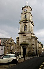
Penryn (; Cornish: Pennrynn, meaning 'promontory') is a civil parish and town in west Cornwall, England, United Kingdom. It is on the Penryn River about 1 mile (1.6 km) northwest of Falmouth. The population was 7,166 in the 2001 census and had been reduced to 6,812 in the 2011 census, a drop of more than 300 people across the ten-year time gap. There are two electoral wards covering Penryn: 'Penryn East and Mylor' and 'Penryn West'. The total population of both wards in the 2011 census was 9,790.Though now the town is overshadowed by the larger nearby town of Falmouth, Penryn was once an important harbour in its own right, lading granite and tin to be shipped to other parts of the country and world during the medieval period.
Excerpt from the Wikipedia article Penryn, Cornwall (License: CC BY-SA 3.0, Authors, Images).Penryn, Cornwall
Helston Road,
Geographical coordinates (GPS) Address Nearby Places Show on map
Geographical coordinates (GPS)
| Latitude | Longitude |
|---|---|
| N 50.169 ° | E -5.107 ° |
Address
Helston Road
Helston Road
TR10 8EN
England, United Kingdom
Open on Google Maps


