Dunkery Hill

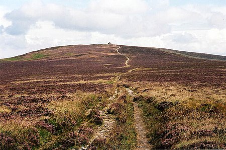
Dunkery Beacon at the summit of Dunkery Hill is the highest point on Exmoor and in Somerset, England. It is also the highest point in southern England outside of Dartmoor. The sandstone hill rises to 519 metres (1,703 ft) and provides views over the surrounding moorland, the Bristol Channel and hills up to 86 miles (138 km) away. The site has been visited by humans since the Bronze Age, and contains several burial mounds in the form of cairns and bowl barrows. Sweetworthy on the lower slopes is the site of two Iron Age hill forts or enclosures and a deserted medieval settlement. The hill is part of a Site of Special Scientific Interest and National nature reserve. It was in private ownership until the 20th century, when it was donated to the National Trust by Sir Thomas Acland, Colonel Wiggin and Allan Hughes; a stone cairn was erected at the summit to commemorate the event.
Excerpt from the Wikipedia article Dunkery Hill (License: CC BY-SA 3.0, Authors, Images).Dunkery Hill
Dicky's Path,
Geographical coordinates (GPS) Address Nearby Places Show on map
Geographical coordinates (GPS)
| Latitude | Longitude |
|---|---|
| N 51.16197 ° | E -3.58736 ° |
Address
Best Star Gazing in Europe
Dicky's Path
TA24 7AT , Luccombe
England, United Kingdom
Open on Google Maps


