place

Llandwrog

Gwynedd geography stubsLlandwrogPages including recorded pronunciationsUse British English from March 2015
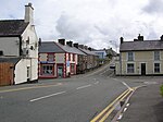
Canol Pentref Llandwrog Village Centre geograph.org.uk 607666

Llandwrog (Welsh pronunciation; Welsh language: meaning 'The church of Saint Twrog') is a village and community in Gwynedd, north-west Wales, most notable for the presence of the headquarters of Welsh record label Sain and the site of Caernarfon Airport. It has a population of 2,466, increasing to 2,539 at the 2011 Census. The community includes the villages of Groeslon, Carmel, Gwynedd, Y Fron, Dinas Dinlle, and Cilgwyn. As suggested by the village name, the parish church is dedicated St Twrog. It was the base of the first ever Sea and Mountain Rescue team, and includes the estate of Glynllifon. RAF Llandwrog was a training airfield during World War II, and was later used as a weapons storage facility. It had a key role in Operation Sandcastle, where a large quantity of Nazi Tabun weapons were stored prior to eventual disposal at sea.

Excerpt from the Wikipedia article Llandwrog (License: CC BY-SA 3.0, Authors, Images).

Geographical coordinates (GPS)

Latitude Longitude
N 53.079 ° E -4.314 °
placeShow on map

Address


LL54 5SY
Wales, United Kingdom
mapOpen on Google Maps

Canol Pentref Llandwrog Village Centre geograph.org.uk 607666
Share experience

Nearby Places

Groeslon
Groeslon

Groeslon (Welsh pronunciation; Welsh: Y Groeslon, "the crossroads") is a small village in the community of Llandwrog in the Welsh traditional county of Caernarfonshire. Groeslon is administered by Gwynedd Council. The population was 880 at the 2011 censusNearby villages are Penygroes, Carmel and Dinas. The village lies approximately five miles south of Caernarfon. It has one primary school in the centre of the village and no secondary schools. Most secondary school age pupils go to Ysgol Dyffryn Nantlle in Penygroes. Groeslon was by-passed in 2002 by the A487 road, a trunk road which cost around £12 million to complete. A bat bridge was constructed in 2010 to guide lesser horseshoe bats across the road. Formerly an agricultural and slate mining village, Groeslon is now expanding as a commuter village for the surrounding towns, especially Caernarfon and Bangor. Its initial growth came as a result of the construction of the LMS railway in 1867. Groeslon railway station closed in December 1964. The railway line is now part of the national cycle route. In the village there is one pub called the Penionyn. At the bottom of the village, bordering the A487, a huge wall becomes visible. This is the wall to the Glynllifon estate, formerly the seat of Lord Newborough, which is now a country park and college (Meirion Dwyfor) specialising in land based industries, e.g. agriculture, equine studies and arboriculture. Groeslon is covered by a Neighbourhood Policing Team based in Penygroes.

Foryd Bay
Foryd Bay

Y Foryd (meaning 'the estuary' or 'the inlet'), also known as Foryd Bay, is a tidal bay in Gwynedd, Wales. It is located at the south-western end of the Menai Strait, about two miles south-west of Caernarfon. Several rivers flow into the bay and there are large areas of mudflats and salt marsh. A shingle spit partly blocks the mouth of the bay. At the north-western end is Fort Belan, built during the 18th century. Aerial photography in the drought of 2018 identified rectangular structures possibly of Roman age, at Glan y Mor, on slightly raised ground adjacent to the shoreline. This layout is very unusual in Roman Wales; it is rectilinear but has no defences and is otherwise unlike the military Roman sites in Wales, nor does it resemble the native defended settlements with their roundhouses and irregular outlines, nor the occasional villas. It is similar to the buildings and ditched enclosures excavated on the other side of the Menai Strait at Tai Cochion. To the south is a rectangular ditched structure or possible building, with an internal subdivision, measuring 25 by 13 m. To the north is a pair of almost identical structures; both groups are linked by a linear ditch or boundary. Close by, an early field system runs north-west to south-east between Plas Farm and the shores of the Menai Strait; the fields are rectangular, with at least one visible ditched hollow way.The bay has been designated a Site of Special Scientific Interest and in 1994 it became a Local Nature Reserve because of its importance for wildlife. Many birds visit in winter and during migration, including large numbers of wildfowl and waders such as wigeon which peak at over 3000 birds. Notable species include brent goose, jack snipe, spotted redshank and greenshank. Terns roost at the mouth of the bay.

Penygroes railway station

Penygroes railway station was located in Penygroes, Gwynedd, Wales.The narrow gauge, horse-drawn Nantlle Railway had a station near the site from 1856. From the outset timetables appeared regularly in the "Carnarvon & Denbigh Herald" and in Bradshaw from October 1856. In 1865 the narrow gauge line was closed, to be replaced and updated to standard gauge with contemporary facilities. It reopened in its eventual form in 1867 and closed in December 1964. The station served as the junction station for the short branch to Nantlle which was overlain in 1872 on part of the former Nantlle Railway route, but its main purpose was for traffic on the former Carnarvonshire Railway line from Caernarvon to Afon Wen and beyond.When the line and station were first opened in 1867 a locomotive was hired from the Cambrian Railways. A Cambrian driver, who had never been over the line before, was retained to drive the first directors' inspection special from Afon Wen to Carnarvon (Pant). On the return journey the loco ran short of coal and ran out of steam at Penygroes. There was some peat in a nearby field, which the crew dug and the directors carried to the engine enabling steam to be raised.The passenger service along the Nantlle Branch was withdrawn in 1932, though excursions continued until 1939. The station and line closed on 7 December 1964 as recommended in the Beeching Report. The station building and footbridge remained in place, but increasingly derelict, until at least 1970.