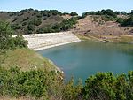
Almaden Quicksilver County Park

Almaden Quicksilver County Park is a 4,163 acres (17 km²) park that includes the grounds of former mercury ("quicksilver") mines adjacent to south San Jose, California, USA. The park's elevation varies greatly: the most used entrances (on the east side of the park) are less than 600 feet (183 m) above sea level, while the highest point in the park is over 1,700 feet (518 m) above sea level. The park is owned by the County of Santa Clara and managed by the Santa Clara County Parks and Recreation Department. Its grounds include the Guadalupe Reservoir and features sweeping views of San Jose. Adjacent to the park is the Almaden Reservoir. The Casa Grande Almaden Quicksilver Mining Museum is located in nearby New Almaden. The park is named after the New Almaden Quicksilver Mines, which were named after the mercury mine in (old) Almadén, Spain, and produced mercury that was used to process ore during the Gold Rush.
Excerpt from the Wikipedia article Almaden Quicksilver County Park (License: CC BY-SA 3.0, Authors, Images).Almaden Quicksilver County Park
New Almaden Trail,
Geographical coordinates (GPS) Address Nearby Places Show on map
Geographical coordinates (GPS)
| Latitude | Longitude |
|---|---|
| N 37.2075 ° | E -121.88083333333 ° |
Address
New Almaden Trail
New Almaden Trail
95120
California, United States
Open on Google Maps


