Clun Forest
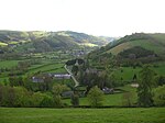
Clun Forest is a remote, rural area of open pastures, moorland and mixed deciduous/coniferous woodland in the southwest part of the English county of Shropshire and also just over the border into Powys, Wales. It was once a Royal hunting forest covering an area that stretched from Ludlow up the Clun Valley. Set aside for hunting in mediaeval times, these areas were not necessarily heavily wooded, though in today's landscape there are numerous small woods, such as Radnor Wood, together with larger areas of conifer plantations established by the Forestry Commission along the Wales–England border north of Anchor for example (the planted Ceri Forest), and to the north and southeast of Clun.The ancient Offa's Dyke runs north–south through the area (and can be walked by the Offa's Dyke Path). It gives its name to a deanery of the Church of England's Diocese of Hereford.
Excerpt from the Wikipedia article Clun Forest (License: CC BY-SA 3.0, Authors).Clun Forest
Geographical coordinates (GPS) Address Nearby Places Show on map
Geographical coordinates (GPS)
| Latitude | Longitude |
|---|---|
| N 52.466666666667 ° | E -3.1333333333333 ° |
Address
SY7 8NH
England, United Kingdom
Open on Google Maps


