Mansfield Woodhouse

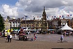
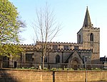
Mansfield Woodhouse is a settlement about 1.2 miles (2 km) north of Mansfield in Nottinghamshire, England, along the main A60 road in a wide, low valley between the Rivers Maun and Meden. Founded before the Roman Empire, it is noteworthy for its stone-built centre. Originally separate with its own urban district council, after continuous development it has become a large part of the Mansfield Urban Area. After the Local Government Act 1972, Mansfield Woodhouse and Warsop Urban District Councils merged with the Municipal Borough of Mansfield on 1 April 1974, to form a new local government area known as Mansfield District Council. Mansfield Woodhouse's economy was traditionally based on the quarrying, mining, farming and textile industries.
Excerpt from the Wikipedia article Mansfield Woodhouse (License: CC BY-SA 3.0, Authors, Images).Mansfield Woodhouse
Springwood Drive,
Geographical coordinates (GPS) Address Nearby Places Show on map
Geographical coordinates (GPS)
| Latitude | Longitude |
|---|---|
| N 53.16 ° | E -1.19 ° |
Address
Springwood Drive
Springwood Drive
NG19 9EB
England, United Kingdom
Open on Google Maps


