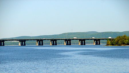
Île aux Tourtes Bridge

The Île aux Tourtes Bridge is a bridge on the western tip of the Island of Montreal, spanning Lake of Two Mountains between Senneville, and Vaudreuil-Dorion, Quebec, Canada. It carries six lanes of Autoroute 40 and is the main transportation link between Montreal and the province of Ontario. At 2 km in length, it is the longest bridge in Quebec to cross a body of water other than the Saint Lawrence River. It is used by 87,000 vehicles per day, or 3.17 million per year, as a vital artery connecting the island of Montreal to its outer suburbs.The bridge has been subject to numerous reparations since the 1990s. With an initial projected end-of-life date of 2002, by 2018, the government of Quebec had spent $87 million to maintain the structure with another $45 million expected to be spent by 2028 to reinforce it while a replacement is built. A new $2.3 billion span is scheduled to open in 2026.
Excerpt from the Wikipedia article Île aux Tourtes Bridge (License: CC BY-SA 3.0, Authors, Images).Île aux Tourtes Bridge
Autoroute Félix-Leclerc,
Geographical coordinates (GPS) Address Nearby Places Show on map
Geographical coordinates (GPS)
| Latitude | Longitude |
|---|---|
| N 45.419555555556 ° | E -73.992111111111 ° |
Address
Autoroute Félix-Leclerc (Autoroute Transcanadienne;Autoroute 40)
Autoroute Félix-Leclerc
H9X 3R3
Quebec, Canada
Open on Google Maps


