place

Ringlestone

Borough of MaidstoneHamlets in KentKent geography stubs
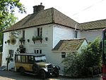
Ringlestone Inn
Ringlestone Inn

Ringlestone is a hamlet between Wormshill and Harrietsham in the Maidstone district of Kent, England. It is in the civil parish of Wormshill. Ringlestone or Rongostone (meaning "ring of stones") dates back to before the Norman conquest of England in 1066 and is mentioned in the Domesday Book of 1086.At the time of the Domesday Survey, the hamlet was smaller than it is today and yet was still deemed worthy of recording as noted by Edward Hasted in his 18th century survey of Kent: On the summit of the hill, at the south-east boundaries of this parish, next to Harrietsham, is a small hamlet, consisting of only three houses, belonging to farms of but small rents, which, however insignificant it may seem now, seems antiently to have been of some account, having been thought of sufficient consequence to be entered in the survey of Domesday, under the title of the possessions of Odo, bishop of Baieux, as follows: Richard holds of the bishop Rongostone, it was taxed at one suling. The arable land is . . . . . There are two villeins, having one carucate, and it paid six shillings in the time of king Edward the Confessor, and afterwards, and now it is worth [f]orty shillings. Ulviet held it of king Edward. Today the hamlet is a collection of cottages and a public house surrounding a former farm, now converted to the Ringlestone Farmhouse Hotel. The Ringlestone Inn, a central feature of the hamlet, is an historic 16th century ale-house.

Excerpt from the Wikipedia article Ringlestone (License: CC BY-SA 3.0, Authors, Images).

Ringlestone
Ringlestone Road,

Geographical coordinates (GPS) Address Nearby Places
placeShow on map

Wikipedia: RinglestoneContinue reading on Wikipedia

Geographical coordinates (GPS)

Latitude Longitude
N 51.270239 ° E 0.692911 °
placeShow on map

Address

Ringlestone Road
ME17 1NX , Wormshill
England, United Kingdom
mapOpen on Google Maps

Ringlestone Inn
Ringlestone Inn
Share experience

Nearby Places

Frinsted
Frinsted

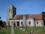
Frinsted or Frinstead is a small village and civil parish in the ecclesiastical parish of Wormshill and in the Maidstone District of Kent, England. and has been a recorded settlement (under the name Fredenestede) as far back as the Domesday Book and indeed was the only settlement in the surrounding area to be described at the time to have a church. The village exists in the Hundred of Eyhorne (and has been mentioned as such dating back to the Kent Hundred Rolls of 1274 to 1275).The parish is situated on the North Downs between Sittingbourne and Maidstone some ten miles (16 km) south of The Swale. To the West lies the village of Wormshill, to the North East the village of Milstead, the hamlet of Kingsdown and the Torry Hill estate and to the South and South East are the villages of Doddington and Newnham. The part of the parish northward of the church is in the division of East Kent, but the church itself, and the remaining part of it is in West Kent.The village is surrounded by former manor houses or "courts" being to the east Wrinsted court and to the west, Yokes Court and Madams Court. The population is relatively unchanged in the past 200 years. In 1801 Frinsted's total population was 153. After rising to 219 around 1871, by the 1901 census the population had dropped to 126. By 1971 the population was 138. At the 2001 census, the population was 171, falling at the 2011 Census to 143.The village church is today dedicated to St Dunstan although an early 19th-century watercolour records it as dedicated to All Saints. Although it has Norman origins, the church as it stands today was constructed principally in the 12th century and was repaired and enlarged in 1862. The bell tower is typical of the Perpendicular Period.