place

Dalby, Isle of Man

Isle of Man geography stubsVillages in the Isle of Man
Niarbyl Bay Isle of Man kingsley 23 JUN 09

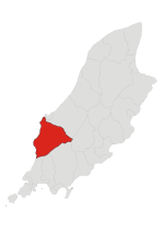
Dalby (Manx: Delbee) is a small hamlet on the Isle of Man, near the western coast. It lies on the A27 Port Erin to Peel road, five miles south of Peel, in the parish of Patrick. The hamlet looks out towards the Irish Sea from the western side of Dalby Mountain. The Raad ny Foillan long distance coastal footpath runs through Dalby. Prior to its closure in 2007, the hamlet had a public house called the Ballacallin Hotel which was known for its views of the sunset over Niarbyl. The hotel later went up in flames on the 9th of February 2021 and was subsequently demolished. Niarbyl is home to a cafe and visitor centre, as well as some traditional Manx cottages. It can be accessed by car, with parking available at the cafe. During World War II, a radar station was located at Dalby. The radar station consisted of a number of bunkers, still visible in the fields between Dalby and Niarbyl and now part of local farm land.

Excerpt from the Wikipedia article Dalby, Isle of Man (License: CC BY-SA 3.0, Authors, Images).

Dalby, Isle of Man
Road of the Tail of Rocks,

Geographical coordinates (GPS) Address Nearby Places
placeShow on map

Wikipedia: Dalby, Isle of ManContinue reading on Wikipedia

Geographical coordinates (GPS)

Latitude Longitude
N 54.16667 ° E -4.73333 °
placeShow on map

Address

Road of the Tail of Rocks (Niarbyl Road)

Road of the Tail of Rocks
IM5 3BS
Isle of Man
mapOpen on Google Maps

Niarbyl Bay Isle of Man kingsley 23 JUN 09
Share experience

Nearby Places

Knockaloe railway station and branch line

Knockaloe railway station served Knockaloe Internment Camp in the Isle of Man between 1915 and 1920. The station was at the end of a short branch line off the Douglas to Peel line of the Isle of Man Railway (IMR). The line left the IoMR on the outskirts of Peel near Glenfaba Mills and climbed steeply in a southerly direction for about 0.7 miles (1.1 km) until it reached the village of Patrick. The line then turned west along the access road into the internment camp which had been built in the grounds of Knockaloe Farm. The total length of the branch line was about 1.2 miles (1.9 km). The branch, and Knockaloe station at its terminus, opened on 1 September 1915 and closed on 14 October 1920. The station and line were used to transport internees, other persons, food and supplies to and from the camp. Few photographs survive of this line, but the locomotive shed is still in existence. In addition to the loco shed, traces include the remains of concrete bridge abutments on the old course of the River Neb at the end of an embankment which crosses a section of ground called the Raggat. The line was worked by the ex-MNR No.4/IMR No.15 0-6-0 locomotive "Caledonia". Materials used to build the line were acquired from an Irish 5' Gauge railway and were removed and shipped off the Island after the line ceased operation. Knockaloe Farm is now government owned. In addition to the line there was a harbour tramway built on the northern side of Peel Harbour running as far as the pier. Pictorial evidence of this is provided by a postcard illustrating 'the sale of fish at Peel'.

South Barrule
South Barrule

The South Barrule (Manx: Baarool Jiass) is the highest hill in the south of the Isle of Man. It has the remains of a fort on its summit, which is traditionally the home of the Manx god of the sea Mannanan beg mac y Leir. The hill is largely surrounded by conifer plantations. On the south western slope of the hill the Cringle Reservoir was formed to supply water to the southern part of the island. South Barrule's ancient name was Warfield or Wardfell. A short, straight footpath links the summit with a small saddle known as the Round Table, through which pass the Bayr ny Skeddan walking route, the A27 Colby to Peel road and the A36 Sloc road. South Barrule is noted for its extensive views from the summit. On clear days, it's possible to make out all four countries of the UK and Ireland at once. Looking south-west lies the Calf of Man, followed by the distant Wicklow Mountains of Ireland. Looking west/north-west, lie the Mourne Mountains and the Glens of Antrim of Northern Ireland. To the north, Snaefell, North Barrule and southern coastline of Scotland are easily visible. To the east, lie the mountains of the Lake District in England. To the south, the northern coastline of Anglesey and more remarkably, on exceptionally clear days, the mountains of Snowdonia and the Great Orme in Wales are all visible. There is also a North Barrule in the Isle of Man. The word Barrule (Manx: Baarool) features in the Manx national anthem, in which the Island is said to be "firm as Barrule".