Colby, Isle of Man
Geography of the Isle of ManVillages in the Isle of Man

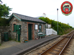
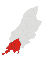
Colby (Manx: Colby) is a small village in the south of the Isle of Man in the parish of Arbory. It lies on the A7 road between the towns of Castletown and Port Erin and close to the similarly sized village of Ballabeg.
Excerpt from the Wikipedia article Colby, Isle of Man (License: CC BY-SA 3.0, Authors, Images).Colby, Isle of Man
Ballacriy Park, Arbory
Geographical coordinates (GPS) Address Nearby Places Show on map
 Continue reading on Wikipedia
 Geographical coordinates (GPS)
| Latitude | Longitude |
|---|---|
| N 54.098 ° | E -4.703 ° |
Address
Ballacriy Park
Ballacriy Park
Arbory
Isle of Man
Open on Google Maps