place

Prerow

Municipalities in Mecklenburg-Western PomeraniaSeaside resorts in Germany
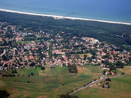
Prerow Luftbild
Prerow Luftbild

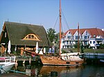
Prerow is a municipality in the district of Vorpommern-Rügen in the German state of Mecklenburg-Vorpommern. This Baltic seaside resort on the Darß peninsula is located about halfway between the historic Hanseatic towns of Rostock and Stralsund. It is one of three main settlements on the Darß, the others being the villages of Born and Wieck. Prerow has fine, sandy beaches and a picturesque landscape. It is hard to say where the forest ends and the village begins. The primeval Darß Forest has over 50 km of footpaths and cycle ways, a bridleway and tracks for horse-drawn carriages. West of the forest is West Beach with rugged terrain formed by wind and waves. South of Prerow is the bodden countryside. Visitors can take trips on a steam paddle boat and experience wildlife first-hand, nesting areas and various birds as the seasons change. The seaside resort of Prerow is located within the Western Pomerania Lagoon Area National Park which stretches from Ahrenshoop along the southern coast to the island of Hiddensee. Prerow itself was a fishing village, but has now been a seaside resort for over 130 years. Thanks to its varied climatic environment with the sea, meadows, forest and reeds, combined with good water quality, it was always recognised as a health spa. In 1998, the Minister of Social and Economic Affairs officially recognized the village as a seaside and health resort.

Excerpt from the Wikipedia article Prerow (License: CC BY-SA 3.0, Authors, Images).

Prerow
Waldstraße, Darß/Fischland

Geographical coordinates (GPS) Address Nearby Places
placeShow on map

Wikipedia: PrerowContinue reading on Wikipedia

Geographical coordinates (GPS)

Latitude Longitude
N 54.446944444444 ° E 12.567777777778 °
placeShow on map

Address

Waldstraße
18375 Darß/Fischland
Mecklenburg-Vorpommern, Germany
mapOpen on Google Maps

Prerow Luftbild
Prerow Luftbild
Share experience

Nearby Places

Zingst
Zingst

Zingst (German pronunciation: [ˈt͡sɪŋst]; Polabian Sgoni) is the easternmost portion of the three-part Fischland-Darß-Zingst Peninsula, located in Mecklenburg-Vorpommern, Germany, between the cities of Rostock and Stralsund on the southern shore of the Baltic Sea. The area is part of the Pomeranian coast. The Zingst Peninsula forms an eastward-running spit, nearly 20 km (12 mi) in length, and has a width of just 2 to 4 km (1.2 to 2.5 mi). Zingst separates the Baltic Sea from the lagoon of Barther Bodden, which is part of the Darss-Zingst Bodden Chain, a large estuary. The shallow waters of the inlet are a major stopover for the migratory European crane. In spring and autumn, up to 3,000 birds gather here on their migration route to and from Spain. Most of the estuary and the eastern end of the peninsula are part of the Western Pomerania Lagoon Area National Park. Until the early 1870s, Zingst was an island, separated from Darß by the Prerowstrom, a narrow inlet. A storm tide in 1874 closed the inlet, which had connected the bodden with the Baltic Sea. A road now connects Zingst and Darß, running along a 100 m (330 ft)-wide isthmus. The soils of Zingst consist almost entirely of sand. The sand is white in colour, which makes it popular with sunbathers and tourists. Dunes border the Baltic Sea and enclose low ground about half a metre below sea level. The low-lying land results in boggy conditions in the interior of the peninsula, and these bogs offer habitat to a wide variety of wildlife. The ruins of a Slavic fort, the 'Hertesburg,' are on the Zingst peninsula near Zingst municipality.

Saal, Mecklenburg-Vorpommern

Saal is a municipality in the Vorpommern-Rügen district, in Mecklenburg-Vorpommern, Germany. The community is under administration of the small city of Barth. Saal has first been documented in a deed of the city of Barth in the year of 1255. At this time there was an already abandoned Slavic castle by the mouth of the Saal creek into the Saal “bodden”. The population around 1255 consisted of indigenous Slav, migrants from Westphalia and Denmark. The first church already existed and was completely made of wood and sanctified to the “Holy Cross”. From today's village Tempel, at the time a commandery, knights templar arrived at Saal. The order of knights was in search to expanding Northeast, and had to take provisions securing its continuity as the Holy Land was lost. The order induced the erection of the church, which until this date dominates impressively the scenery and gives a different impression of Gothic architecture. Everything at this church is characterized by ‘shiftings’: windows, portals. The frayed walls are evidence of both planned or symbolic annexes and continued constructions. The entry to the underground walkway, behind the altar, can still be seen. It is said to end somewhere by the “bodden”. Underneath the bell tower (1731) standing aside from the actual church, is a hollow space, which however, had never been explored. According to the legend a part of the templar treasure was brought here around 1300. One of the templar stole a part of the treasure and hid it in one of the column foundations. It was said to be the vanished imperial regalia of John Lackland, which he lost in unclear circumstances in 1216. Legend: Until 1309 the templar rebuilt the castle at the „bodden“ and used it as a port facility. Today, only the castle ramparts testify of the once great times. The Vitalian Brotherhood under Stoertebeker (.../succession order of the templar in Portugal) had used the castle until 1391 and are said to have brought the treasure under the bell tower to this place. After they were involved in a fight with the Danes on the Ribnitz Sea, they had to flee and never returned to Saal. The treasure is said to be still somewhere there. Today the templar in Saal are forgotten; only Stoertebeker is sometimes spoken about. Suggestion: Who ever comes to Saal, should not miss visiting an ancient stone circle, the apostle stones.