place

Cordwainer (ward)

Use British English from November 2014Wards of the City of London
City of London, Ward of Cordwainer

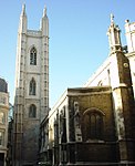
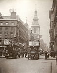
Cordwainer is a small, almost rectangular-shaped ward in the City of London. It is named after the cordwainers, the professional shoemakers who historically lived and worked in this particular area of London; there is a Livery Company for the trade — the Worshipful Company of Cordwainers. The ward is sometimes referred to as the "Cordwainers' ward". It is bounded to the north by Poultry and Cheapside (the boundary with Cheap ward); to the west by the eponymous Bread Street and the ward of the same name; to the south by Cannon Street (and Vintry and Dowgate wards); and to the east by Walbrook ward and a street of the same name. Streets within Cordwainer's boundaries are, amongst others, Bow Lane, Pancras Lane and part of Watling Street. Queen Street runs north–south through the centre of the ward.

Excerpt from the Wikipedia article Cordwainer (ward) (License: CC BY-SA 3.0, Authors, Images).

Cordwainer (ward)
Watling Street, City of London

Geographical coordinates (GPS) Address Nearby Places
placeShow on map

Wikipedia: Cordwainer (ward)Continue reading on Wikipedia

Geographical coordinates (GPS)

Latitude Longitude
N 51.51285 ° E -0.09324 °
placeShow on map

Address

St Mary Aldermary

Watling Street
EC4M 9BW City of London
England, United Kingdom
mapOpen on Google Maps

City of London, Ward of Cordwainer
Share experience

Nearby Places

Queen Street, London

Queen Street is a street in the City of London which runs between Upper Thames Street at its southern end to Cheapside in the north. The thoroughfares of Queen Street and King Street (a northward continuation of Queen Street beyond Cheapside) were newly laid out, cutting across more ancient routes in the City, following the Great Fire of London in 1666; they were the only notable new streets following the fire's destruction of much of the City.At the lower (southern) end of Queen Street is Southwark Bridge. The London Chamber of Commerce & Industry is located at No. 33. At the upper (northern) end the street crosses Cheapside and becomes King Street, which leads to Gresham Street and the Guildhall. This creates a direct route from the River Thames at Southwark Bridge up to the Guildhall. Queen Street meets the newer Queen Victoria Street as well as Cannon Street. Minor roads off the street include Skinners Lane (the home of the Worshipful Company of Skinners) and Cloak Lane. Two short sections of the street are pedestrianised, which together with a pedestrian-priority crossing of Cannon Street, forms a "Central Plaza" area. This was part of an award-winning public realm improvement scheme undertaken in 2006. This pedestrianised part of Queen Street has been used as a location for a number of art events organised by the City of London Festival and the London Architectural Biennale. Queen Street and King Street form part of an important route on the London Cycle Network which continues south over Southwark Bridge and north towards Moorgate. Queen Street runs through the wards of Vintry and Cordwainer, and is in the postal code area EC4. King Street is in the ward of Cheap and in postcode area EC2. King Street formed part of the marathon course of the 2012 Olympic and Paralympic Games. The women's Olympic marathon took place on 5 August and the men's on 12 August. The four Paralympic marathons were held on 9 September.

Honey Lane Market
Honey Lane Market

Honey Lane Market was an historic market near Cheapside in the City of London.It was built at the south end of Milk Street on the site of the parish church of St Mary Magdalen and All Hallows Honey Lane after the areas destruction in the Great Fire of London in 1666, and the market took over the area. The market at one time had 105 butchers' stalls. Edward Hatton noted in 1708 that the market was known for its meat, fish, and poultry.By 1835, the City of London School was built on part of the market site facing Milk Street on the corner with Russia Row. It was paid for with money bequeathed for the purpose by John Carpenter, city clerk in the reign of King Henry V. The school grew rapidly and in 1883 it moved to larger quarters on the Victoria Embankment.It was noted in 1927 that the market "retains much of its original semi-enclosed plan". There were many food shops, "though wholesale premises are gradually encroaching on the space".Honey Lane was completely destroyed and the surrounding area seriously damaged by German bombing on 29 December 1940.In the postwar reconstruction the market fell within a parcel of land (along with Milk Street Buildings, Freeman's Court, Trump Street and Lawrence Lane) covering 53,434 square feet, referred to as No. 11. The cost of reconstruction of the parcel of land was estimated at £520,500 (in 1952) with costs to tax payers turned into a surplus by 2013.The current Honey Lane, a breezeway, is approximately 100 feet east of the old one and connects Cheapside and Trump Street.