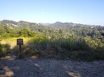
San Pablo Ridge
Contra Costa County, California geography stubsMountain ranges of Contra Costa County, CaliforniaMountain ranges of the San Francisco Bay AreaOrinda, CaliforniaPinole, California
San Pablo Ridge is a small mountain range in western Contra Costa County from Pinole to Orinda between Wildcat Canyon and San Pablo Canyon. The western flank is part of the Wildcat Creek watershed and the eastern flank is part of the San Pablo Creek watershed. To the west are the Berkeley Hills, and to the east, the Sobrante Ridge. The highest point on the San Pablo Ridge is Vollmer Peak (elevation 1,905 feet/581m), formerly called "Bald Peak", located near the point where it meets the Berkeley Hills at the head of Wildcat Canyon. San Pablo Ridge is largely undeveloped, forming part of county lands and open space, with a few privately held ranches remaining.
Excerpt from the Wikipedia article San Pablo Ridge (License: CC BY-SA 3.0, Authors).San Pablo Ridge
Nimitz Way, Richmond
Geographical coordinates (GPS) Address Nearby Places Show on map
Geographical coordinates (GPS)
| Latitude | Longitude |
|---|---|
| N 37.935202 ° | E -122.2705246 ° |
Address
Nimitz Way
Nimitz Way
94530 Richmond
California, United States
Open on Google Maps


