place

Carmel Hamlet, New York

Census-designated places in New York (state)Census-designated places in Putnam County, New YorkCounty seats in New York (state)Hamlets in New York (state)Hamlets in Putnam County, New York
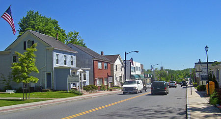
Downtown Carmel, NY
Downtown Carmel, NY

Carmel Hamlet, commonly known simply as Carmel, is a hamlet and census-designated place (CDP) located in the Town of Carmel in Putnam County, New York, United States. As of the 2010 census, the population was 6,817.The hamlet is the site of the historic County Court House (built 1814), the David D. Bruen County Office Building, and other structures, and borders Lake Gleneida. Next to the lake stands a bronze statue commemorating Sybil Ludington.

Excerpt from the Wikipedia article Carmel Hamlet, New York (License: CC BY-SA 3.0, Authors, Images).

Carmel Hamlet, New York
Gleneida Avenue,

Geographical coordinates (GPS) Address Nearby Places
placeShow on map

Wikipedia: Carmel Hamlet, New YorkContinue reading on Wikipedia

Geographical coordinates (GPS)

Latitude Longitude
N 41.426111111111 ° E -73.678888888889 °
placeShow on map

Address

Putnam County Courthouse

Gleneida Avenue 44
10512
New York, United States
mapOpen on Google Maps

Downtown Carmel, NY
Downtown Carmel, NY
Share experience

Nearby Places

West Branch Reservoir

The West Branch Reservoir is a reservoir in the New York City water supply system. Formed by impounding the upper reaches of the West Branch of the Croton River, it is located in the Putnam County, New York, towns of Kent, and Carmel, about 50 miles (80 km) north of New York City.Put into service in 1895, West Branch is one of 12 reservoirs in the system's Croton Watershed, and second northernmost. It receives the flow of the upstream Boyds Corner impoundment, and, when needed, of Lake Gleneida, a controlled lake in the City supply system. Primarily, however, it receives water from the much larger Rondout Reservoir in the Catskill Mountains on the west bank of the Hudson River via the Delaware Aqueduct. It serves as a supplementary settling basin for these waters before releasing its flow back into the aqueduct to be carried to the Kensico Reservoir in southern Westchester County.West Branch Reservoir has a 20 square mile (32 km²) drainage basin, and can hold up to 8 billion US gallons (30,000,000 m3) of water at full capacity. It consists of two basins, separated by State Route 301.During drought periods the West Branch also receives water pumped in from the Hudson River by the City's Chelsea Pumping Station near Beacon in Dutchess County, some 65 miles (105 km) from New York City. It was used for this purpose during the 1965–66 and 1985 droughts, as well as during May 1989. Water withdrawn from the West Branch ordinarily flows via the Delaware Aqueduct to the Kensico Reservoir in Westchester County for further settling. There it mixes with additional Catskill system water carried by the Catskill Aqueduct before entering tunnels that carry it to the Hillview Reservoir in Yonkers, at the City's northern boundary. There it enters the city's direct water supply distribution system, flowing via tunnels through the boroughs of The Bronx, Queens, and Brooklyn. The water finally stops at Staten Island. Water in excess of New York City's needs at the West Branch Reservoir goes over its spillway and into the West Branch Croton River, which is captured downstream by the Croton Falls Reservoir.

Tilly Foster Mine
Tilly Foster Mine

The Tilly Foster Mine was an iron mine in the Town of Southeast in Putnam County, New York, USA, two miles west of the village of Brewster along Route 6. The Tilly Foster Mine was named for Tilly Foster, who bought the land that the mine was on from George Beale. After Foster's death in 1842, the property passed through several hands before it came into the possession of Harvey Iron and Steel Company. The mine opened in 1853 and employed large numbers of Irish and Italian immigrants. The jobs available at the mine played a large part in bringing immigrants to the town of Southeast. Workers were known by numbers rather than names, because the names of immigrants were considered too difficult to pronounce. The mine reached its peak of production in the 1870s. It was 600 feet (180 meters) deep. There were 300 miners employed and they were producing 7,000 tons (14,000,000 pounds) of ore per month. The main minerals were magnetite and chondrodite. The iron ore was loaded onto a train to New York City. Large quantities of Bessemer ore were shipped to Scranton, Pennsylvania, and used to make steel rails for the Lackawanna Steel Company. From 1887 to 1889, the mine was made into an open pit. At one time, it was the largest open-pit operation in the world. In 1895, there was a major collapse that killed 13 miners. After the collapse it was flooded by a reservoir nearby. It was used by soldiers in World War II to test their diving equipment. A collection of minerals and artifacts from the mine is at the Southeast Museum in Brewster. On November 19, 2017, Robert Thomas, 48, went scuba diving at Tilly Foster Mine. He went down without a "buddy" to a depth of 171 feet, became entangled in wires and cables, and never resurfaced. His body was recovered at about 1:00 p.m. the day after he went missing. He and other divers had an agreement with owners of the property to dive at the mine.