Gungahlin

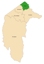
Gungahlin () is a district in the Australian Capital Territory, one of fastest growing regions in Australia. The district is subdivided into suburbs, sections and blocks. Gungahlin is an Aboriginal word meaning either "white man's house" or "little rocky hill".As of 2022 Gungahlin comprised sixteen suburbs, including several under construction and a further suburb planned. The town of Gungahlin was part of the original 1957 plan for development in the ACT and in 1991 was officially launched as the fourth 'town' by the ACT Chief Minister. At the time, the population of Gungahlin was just 389 residents. At the 2021 census, the population of the district was 87,682.Within the district is the northernmost town centre of the ACT, situated 10 kilometres (6 mi) north of Canberra City ("Civic" in the local parlance); one of five satellite cities of the ACT, with Woden, Tuggeranong, Weston Creek and Belconnen.
Excerpt from the Wikipedia article Gungahlin (License: CC BY-SA 3.0, Authors, Images).Gungahlin
Anthony Rolfe Avenue,
Geographical coordinates (GPS) Address Nearby Places Show on map
Geographical coordinates (GPS)
| Latitude | Longitude |
|---|---|
| N -35.1831 ° | E 149.133 ° |
Address
Anthony Rolfe Avenue
Anthony Rolfe Avenue
2912 , Gungahlin
Australia
Open on Google Maps


