place

Paddlesworth

Civil parishes in KentFolkestone and Hythe DistrictKent geography stubsVillages in Kent
Paddlesworth village sign

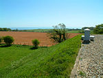
Paddlesworth is a hamlet and parish located about 3 miles (4.8 km) NNW of Folkestone in Kent, England, near Hawkinge. Paddlesworth was a sighting-point for the Anglo-French Survey (1784–1790) linking the Royal Greenwich Observatory with the Paris Observatory, undertaken by General William Roy. A chain of readings was made from high points between the two observatories, including locally from Dover Castle, St Peter's Church, Swingfield, and Aldington Knoll. The Early Norman Anglican parish church is dedicated to St Oswald. It was built in the 11th century or earlier but underwent alteration in the 13th and restoration in the 19th century. It has been designated as a Grade I listed building.It is said of Paddlesworth that it has the "Highest Church, Lowest Steeple, Poorest Parish, Fewest People". These words can be seen carved in a circle round the edge of the village sign, as seen in the photo above right. The public house is 'The Cat and Custard Pot', two elements illustrated on the village sign.From September to December 2010 a group of writers and artists created the Paddlesworth Press, a "mixed-media, collaborative online novel" based on Paddlesworth with fictional characters and events in a spoof newspaper.

Excerpt from the Wikipedia article Paddlesworth (License: CC BY-SA 3.0, Authors, Images).

Paddlesworth
Folkestone and Hythe District

Geographical coordinates (GPS) Address Nearby Places
placeShow on map

Wikipedia: PaddlesworthContinue reading on Wikipedia

Geographical coordinates (GPS)

Latitude Longitude
N 51.115 ° E 1.137 °
placeShow on map

Address


CT18 8AD Folkestone and Hythe District
England, United Kingdom
mapOpen on Google Maps

Paddlesworth village sign
Share experience

Nearby Places

Cheriton Hill
Cheriton Hill

Cheriton Hill is a hill overlooking the English Channel near Folkestone in the south-east corner of Kent, England. The relatively low-lying hill (reaching only 188 metres above sea level) is covered with farmland, villages, narrow lanes, and footpaths. The highest point is on a covered reservoir next to the trig point; the highest natural point is nearby, probably close to the road to the village of Paddlesworth, near a transmitter mast, but the relatively flat summit gives no real impression of being on top of a hill. By contrast, the southern edge of the hill is a steep escarpment which carries the ancient track named Pilgrims' Way, which is believed to date from 500–450 BC, and which runs from Folkestone along the North Downs hills. At this point the escarpment overlooks the huge Cheriton Channel Tunnel terminal, with views to France across the roofs of Folkestone. The slope of this escarpment forms part of the Folkestone Downs and is the location of the Folkestone White Horse, completed in 2003. Cheriton Hill was the location of the discovery of the Late Spider orchid in the 19th century. At one point the number of known plants at Folkestone/Cheriton declined to just six, but with improved management of the chalk grassland by Eurotunnel and the White Cliffs Countryside Project, the population is now much healthier, estimated in 2008 to be 165 plants, some 30% of the UK population. Cheriton Hill is one of the Marilyns identified since the publication of The Relative Hills of Britain in 1992, and is the most easterly Marilyn.

Folkestone White Horse

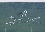
The Folkestone White Horse is a white horse hill figure, carved into Cheriton Hill, Folkestone, Kent, South East England. It overlooks the English terminal of the Channel Tunnel and was completed in June 2003.The horse was planned as a Millennium Landmark to help regenerate the Folkestone area. The design for the horse was drawn by a local artist, Charlie Newington, inspired by a nearby Iron Age fort in an area known as Horse Hill dating from three millennia ago and also based on the White Horse of Uffington. It is the first official hill figure in the town, although an area of chalk on Summerhouse Hill is said to resemble an elephant's head and has become known as the Folkestone Elephant.Planning permission for the project was first applied for in April 1998, with an illustrative canvas mockup being erected in August 1999. The project was opposed by the Government watchdog English Nature due to the site's importance as a Site of Special Scientific Interest. In 2000 English Nature appealed to Deputy Prime Minister John Prescott, although the project was said to have widespread public support by local MP and prominent politician Michael Howard. The project was supported by Folkestone & Hythe District Council, who adopted it as their corporate logo. Due to the opposition, the project went to a public enquiry in 2001. The project was given the go-ahead in March 2002 by Stephen Byers, then Secretary of State for Transport, Local Government and the Regions, who stated that the emotional and symbolic value of the project outweighed the possible environmental damage.Construction of the horse began in September 2002. The work to build the horse was completed entirely by hand. Directed from afar by the artist via radio, a team of volunteers staked out a second canvas template of the horse, and following this, shallow trenches were then dug into the topsoil, 12–24 inches (30–60 cm) wide. These trenches were then filled with limestone slabs. The entire figure is approximately 90 metres long, measured from the front to the rear hoof. Both the Green Party and Friends of the Earth appealed to the European Union to stop the project based on the site's protection under the European Habitats Directive. In early May 2003 the EU issued a formal notice to the UK Government declaring the work illegal, and giving the government two months to either explain the 2001 enquiry decision satisfactorily, or restore the site, by which time the turf for the horse had already been cut and transplanted.Over two weeks in May 2003 a team of volunteers including locally based Gurkha soldiers transported, cut and positioned limestone slabs in the trenches, fixing them in place with pins. The limestone laying phase of the construction, which had been delayed when the Gurkhas were needed to crew fire engines during the 2002–2003 Firemen's strike, was completed in early June 2003, with the formal notice from the EU outstanding.In June 2004 "The Friends of the Folkestone White Horse" was formed, to promote the landmark and look after the site, which requires periodic light weeding. A time capsule was buried on the site on 18 June 2004.

Acrise Place
Acrise Place

Acrise Place is a mainly 18th-century house located about 6 miles (9.6 km) north of Folkestone in the village of Acrise, Kent, England. It is a Grade II* listed building.It is a brick-built house dating from the 16th century, with modifications in 1671 and 1691, and which was restored in the 1950s and 1987. There are two parallel ranges, a 16th-century north-facing range and a 17th-century south-facing range. It was originally built by the Hamon family in the 16th century, but acquired in 1666 by Jane and Thomas Papillon for about £6,000. Jane managed this property and their town house. Her letter from 1667 and 1668 are extant. The house and estate were passed down in that family for several generations. Two of the Papillon owners were Philip and David Papillon, father and son, who were both MPs for nearby Dover. In 1850 the Papillons sold Acrise to William Mackinnon MP after whose death it was sold in 1908 to the Walney family, who occupied it until 1936. After standing empty for a time the house was used by the Army during the war and repurchased by the Papillons in 1946. On 29 July 1944, Flight Sgt Anthony Drew of 56 Squadron RAF, while pursuing a V1 Flying Bomb in a Hawker Tempest, became disoriented in cloud and crashed into the ground, narrowly missing the house. Drew's remains and some wreckage of his Hawker Tempest were recovered the next day. Drew had previously shot down 3 V-1s. The Folkestone Building Company purchased the property in 1986 and undertook a major programme of restoration of the main house. They also converted the 18th century stable blocks and ancillary buildings to exclusive residential units. The main house is now divided into two separate properties, Acrise Place and Acrise Court.The 18th-century stable block is a separately listed Grade II listed building.