place

Roxbury, New Jersey

1740 establishments in New JerseyFaulkner Act (council–manager)Populated places established in 1740Roxbury, New JerseyTownships in Morris County, New Jersey
Use American English from March 2020Use mdy dates from March 2020
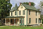
CARY STATION, LEDGEWOOD, MORRIS COUNTY

Roxbury is a township in Morris County, in the U.S. state of New Jersey. As of the 2020 United States census, the township's population was 22,950, a decrease of 374 (−1.6%) from the 2010 census count of 23,324, which in turn reflected a decline of 559 (−2.3%) from the 23,883 counted in the 2000 census. The township is located approximately 36 miles (58 km) west-northwest of New York City, 27 miles (43 km) west-northwest of Newark, New Jersey and 26 miles (42 km) east of the Delaware Water Gap on the border of New Jersey and Pennsylvania. Roxbury was formed on December 24, 1740, from portions of Morris Township. It was formally incorporated by the Township Act of 1798 of the New Jersey Legislature on February 21, 1798, as part of the state's initial group of 104 townships. Portions of the township were taken to form Mendham Township (March 29, 1749), Washington Township (April 2, 1798), Chester Township (April 1, 1799), Jefferson Township (February 11, 1804), Mount Olive Township (March 22, 1871), Mount Arlington (November 3, 1890) and Netcong (October 23, 1894).Tom's Diner was featured in the music video from Time After Time by Cyndi Lauper.

Excerpt from the Wikipedia article Roxbury, New Jersey (License: CC BY-SA 3.0, Authors, Images).

Roxbury, New Jersey
Salmon Lane,

Geographical coordinates (GPS) Address Nearby Places
placeShow on map

Wikipedia: Roxbury, New JerseyContinue reading on Wikipedia

Geographical coordinates (GPS)

Latitude Longitude
N 40.88841 ° E -74.651497 °
placeShow on map

Address

Salmon Lane

Salmon Lane
07852
New Jersey, United States
mapOpen on Google Maps

CARY STATION, LEDGEWOOD, MORRIS COUNTY
Share experience

Nearby Places

Mount Arlington station

Mount Arlington (also known as the Howard Boulevard Park and Ride) is a commuter railroad station for New Jersey Transit. Located in the borough of Mount Arlington, Morris County, New Jersey, United States, the station is located next to interchange 30 on Interstate 80. The station serves as a park-and-ride for commuters to catch trains for Hoboken Terminal and New York Penn Station. Trains use the Montclair-Boonton Line and Morristown Line to serve locales between Hackettstown and the eastern terminals. Lakeland Bus Lines also services Mount Arlington station. The station is handicapped accessible as part of the Americans with Disabilities Act of 1990. The station features two side platforms and two tracks with elevators. Railroad history in Mount Arlington began on January 16, 1854, with an extension of the Morris and Essex Railroad from Dover to Hackettstown. The station was established 0.5 miles (0.80 km) west of the current station under the name of Drakesville. The station was renamed on July 1, 1891 from Drakesville to Mount Arlington. A new station was opened later that year. Passenger service ended at Mount Arlington on November 8, 1942 and service was merged with nearby Lake Hopatcong station in Landing. The current station at Mount Arlington began construction on June 12, 2006 with a groundbreaking ceremony headlined by Rodney P. Frelinghuysen (R–NJ). This new station would join a park and ride already built for buses at Howard Boulevard (Morris County Route 615). Despite a slated 2007 opening, the station opened to the public on January 21, 2008.

Lake Hopatcong station

Lake Hopatcong is a commuter railroad station for New Jersey Transit. The station, located in the community of Landing in Roxbury Township, Morris County, New Jersey, United States, serves trains for the Montclair-Boonton Line and Morristown Line at peak hours and on holiday weekends. Service from Lake Hopatcong provides to/from Hackettstown to New York Penn Station and Hoboken Terminal. The stop is located on the tracks below Landing Road (Morris County Route 631) next to the eponymous Lake Hopatcong. The station consists of one active and one abandoned side platform, along with a shelter on the active platform. There is no accessibility for handicapped persons under the Americans with Disabilities Act of 1990. Service through the Landing area began on January 16, 1854, for the Morris and Essex Railroad, but there was no stop at the shore of Lake Hopatcong. People who wanted to visit the lake had to get off at nearby Drakesville station and traverse from there to the lake. In 1882, after the Central Railroad of New Jersey built the Wharton and Northern Railroad to Charlotteburgh, there was added incentive to bring a station to the Lake Hopatcong area. The Delaware, Lackawanna and Western Railroad, which took over the Morris and Essex tracks, established a stop in Landing in 1882. In 1910, service began by the Morris County Traction Company, an electric trolley railroad.The Lackawanna Railroad announced on July 15, 1910, that a new station would be built at Lake Hopatcong, just east of the nearby county bridge. The new station opened on May 28, 1911, a new all-concrete structure with two elevators and a complete walkway on the south side of the Morris Canal. Service on the Lackawanna Cut-Off, a new mainline just west at Port Morris, opened on December 24, 1911. The concrete overpass was demolished in 1982, after being condemned in 1978. The station depot on Landing Road continues to stand.