place

Jeremy River

Rivers of ConnecticutRivers of New London County, ConnecticutRivers of Tolland County, ConnecticutTributaries of the Connecticut River
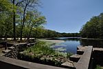
Norton Mill Dam Removal (37466593632)

The Jeremy River, named after Jeremy Adams, begins at a drainage just north of Holbrook Pond about 1.5 miles (2.4 km) east of Gilead, Connecticut and runs for 10.7 miles (17.2 km) to the Salmon River in Colchester, Connecticut. There are many swamps and marshes along the banks of its northern end, the largest of which is 1.5 miles (2.4 km) long. There is a popular paddling route along the Jeremy River that begins at Old Hartford Road just north of Connecticut Route 2 about 3 miles (5 km) west-northwest of Colchester. The 2.5-mile (4.0 km) route has solid Class II whitewater throughout the run and ends at the Salmon River; however, many paddlers continue along the Salmon River paddling route. The Norton Paper Mill is located on Jeremy River (in Colchester, Connecticut). It operated from 1895 until the early 1960s, before becoming abandoned by the early 1980s, and falling into disrepair. A fire engulfed the building on July 8, 2012, consuming most of the remaining combustibles (the largely-intact walls being made of brick). The property was purchased by the Town of Colchester in 2015 (for $1), with plans to remove the building and redevelop the site as a public park. The Nature Conservancy in Connecticut removed the adjacent dam in 2016.

Excerpt from the Wikipedia article Jeremy River (License: CC BY-SA 3.0, Authors, Images).

Jeremy River
Old Hartford Road,

Geographical coordinates (GPS) Address Nearby Places
placeShow on map

Wikipedia: Jeremy RiverContinue reading on Wikipedia

Geographical coordinates (GPS)

Latitude Longitude
N 41.58829 ° E -72.3848 °
placeShow on map

Address

Old Hartford Road 639
06415
Connecticut, United States
mapOpen on Google Maps

Norton Mill Dam Removal (37466593632)
Share experience

Nearby Places

Colchester Village Historic District

The Colchester Village Historic District encompasses most of the historic village center of Colchester, Connecticut. It is located at the junction of Route 16, Route 85, and Norwich Avenue (old Route 2). Roughly, the district extends to the northwest along Broadway Street (Route 85) as far as Jaffe Terrace; east along Norwich Avenue to just short of Pleasant Street; south along South Main Street to just north of Hall Hill Road; west along Linwood Avenue (Route 16) to just east of Kmick Lane. The historic district was listed on the National Register of Historic Places (NRHP) in 1994. The Colchester Town Green is located at the center of the district. Several commercial, residential and civic buildings mostly from the 19th century, surround the green, with the Colchester Federated Church in the Greek Revival style and the Bacon Academy (built in 1803 and separately listed on the NRHP) being the dominant structures. The Hayward House (built in 1767 and separately listed on the NRHP) is located on Hayward Avenue across the street from the green and is now being used as a bed and breakfast. Wheeler Block, the original town hall and also listed separately on the NRHP, is located across the green to the south on Norwich Avenue.Colchester was incorporated in 1698 and was at first a dispersed agricultural community. The village center formed around the town's first colonial meeting house and burying ground, with the area's economic importance later cemented by its location as a crossroads of several early 19th century turnpikes. Bacon Academy was founded in 1803 as the region's first secondary school, and the town was home to the first Masonic lodge in the region (founded 1782). In the second half of the 19th century, the village benefited from the rise of small industries, prompting the construction of a number of commercial buildings, including the fine Second Empire Wheeler Block.