place

Boskoop

Alphen aan den RijnFormer municipalities of South HollandMunicipalities of the Netherlands disestablished in 2014Pages with non-numeric formatnum argumentsPopulated places in South Holland
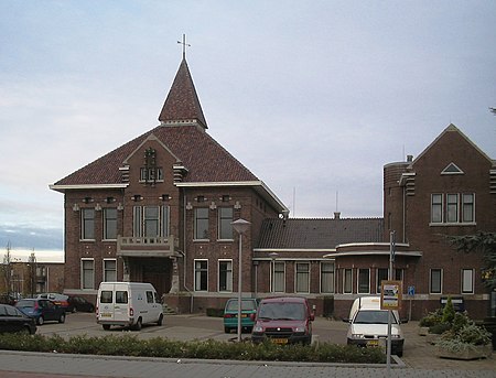
Boskoop stadshuis
Boskoop stadshuis

Boskoop (Dutch pronunciation: [ˈbɔskoːp] (listen)) is a town in the province of South Holland. It was a separate municipality until it merged into Alphen aan den Rijn in 2014. The town had a population of 15,050 in 2012 and covers an area of 7.29 km2 (2.81 sq mi) of which 1.39 km2 (0.54 sq mi) is water. It's the world's biggest joined floriculture area. Boskoop is famous for its nurseries, particularly woody plant and perennial nurseries, of which some 774 are situated on long stretches of land, divided by narrow canals. Before World War II almost all transport was conducted using narrow boats. A few exceptionally high footbridges crossing some of the broader (main) canals remain from these days. Between the World Wars the transition was made from fruit culture to decorative garden plants and trees. As a source of technical knowledge about the art of growing decorative plants, Boskoop remains world-renowned and unique. The name "Boskoop" has been given to an apple cultivar (Belle de Boskoop) which is widely distributed in the Low Countries, to a grape variety (Boskoop Glory) and also to a variety of Calluna (Boskoop) and Weigela (Boskoop Glory) and blackcurrant ("Boskoop Giant").

Excerpt from the Wikipedia article Boskoop (License: CC BY-SA 3.0, Authors, Images).

Boskoop
J.C. Bulkstraat, Alphen aan den Rijn

Geographical coordinates (GPS) Address Nearby Places
placeShow on map

Wikipedia: BoskoopContinue reading on Wikipedia

Geographical coordinates (GPS)

Latitude Longitude
N 52.066666666667 ° E 4.65 °
placeShow on map

Address

J.C. Bulkstraat 9
2771 JD Alphen aan den Rijn
South Holland, Netherlands
mapOpen on Google Maps

Boskoop stadshuis
Boskoop stadshuis
Share experience

Nearby Places

Tempel, Berkel en Rodenrijs

Tempel, also known as De Tempel, is a former municipality and former manorial estate in the Dutch province of South Holland. It was located about 3 km southwest of the center of the current village of Berkel en Rodenrijs. According to the 19th-century historian A.J. van der Aa, Tempel was named after a manor house that used to be located in the area. around the beginning of the 19th century, the house was long gone. In nearby Overschie an estate can be found where in the 18th century the owner of Tempel used to live. He acquired it in 1715, after which the house Berkeloord was renamed to De Tempel. The manorial rights of Tempel were also applicable at the estate, even though it was located outside of its territory. After the introduction of the municipal system by the French in 1812, the area belonged to the municipality of Pijnacker, even though it was completely surrounded by the territory of Berkel en Rodenrijs. In 1817, the manorial rights were restored, and Tempel became a separate municipality, although it was very small (only 0.109 km2) and had no inhabitants. This was not a problem, as long as the lord of the area was prepared to pay for the municipal government. In 1855, the municipality became part of Berkel en Rodenrijs. Since 2007, Tempel is a part of Lansingerland, when Berkel en Rodenrijs merged with Bergschenhoek and Bleiswijk. The coat of arms of the manor and former municipality of Tempel depict a silver portal (i.e. a temple entrance), on a shield of gules. The flag is an armorial banner, with the portal placed off-center, towards the hoist.