place

Düsseldorf-Reisholz

Düsseldorf region geography stubsUrban districts and boroughs of Düsseldorf
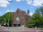
Verkuendigungskirche in Duesseldorf Reisholz, von Westen

Reisholz is an urban borough of Düsseldorf. It is located in the south of the city, bordering Holthausen, Benrath, Hassels and the river Rhine. Reisholz is an industrial part of the city. Its history started in 1905 by creation of a harbour to the Rhine, a goods station and an industrial area by the Industrie-Terrains Düsseldorf-Reisholz (IDR) company. Many chemical factories, engine building industries, paper mills, petrochemical manufacturers and an oil refinery went to Reisholz. In 1907 the IDR company built a neogothic church. It was demolished, when the Henkel Company expanded in Reisholz, but Henkel built a new church for Reisholz. Reisholz belonged to Benrath and became a part of Düsseldorf together with Benrath in 1929. In the harbour of Reisholz there are plans for a new business and living area.

Excerpt from the Wikipedia article Düsseldorf-Reisholz (License: CC BY-SA 3.0, Authors, Images).

Düsseldorf-Reisholz
Spangerstraße, Dusseldorf Hassels (Stadtbezirk 9)

Geographical coordinates (GPS) Address Nearby Places
placeShow on map

Wikipedia: Düsseldorf-ReisholzContinue reading on Wikipedia

Geographical coordinates (GPS)

Latitude Longitude
N 51.176388888889 ° E 6.8658333333333 °
placeShow on map

Address

Spangerstraße 34
40599 Dusseldorf, Hassels (Stadtbezirk 9)
North Rhine-Westphalia, Germany
mapOpen on Google Maps

Verkuendigungskirche in Duesseldorf Reisholz, von Westen
Share experience

Nearby Places

Düsseldorf-Holthausen

Holthausen is an urban borough of Düsseldorf. It is located south of Oberbilk, west of Reisholz, north of Benrath and east of Itter and Himmelgeist. A natural border is the river Rhine. Holthausen's history is connected to the history of Itter, Himmelgeist, Benrath, Wersten and Bilk. Until the 18th century its name was Langenweyer. First settlements in that area were formed in the 9th century before Christ, with continuous settlements existing since the 2nd century after Christ. The name Holthausen was mentioned first time about 1700. Until the beginning of the industrial revolution, Holhausen was a small village. It changed after the Henkel Company opened its headquarters in Holthausen. In 1823 Holthausen had 322 inhabitants; in 1869 – 384; in 1895 – 556 people lived in Holthausen; 1905 – 1,884 people. Holthausen's population was at its largest in 1969 – 15,000 inhabitants. Around 12,000 people live there today. From 1909 to 1929 Holthausen was a part of Benrath and in 1929 it became part of Düsseldorf. Holthausen still has some important industrial head offices today, as Henkel is still in Holthausen, right next to the Cognis Group HQ. There are two underground lines (U74 and U77), two tram lines (701 and 713) as well as the bus lines (724, 789, 817, 835 and NE7) in Holthausen. Holthausen is connected to the federal highway A 46 (Neuuss- Düsseldorf - Wuppertal) and the federal road B 8 goes across it. In the south of Holthausen there is a great forest area, the Heyepark and a sports park. This article is based on a translation of an article from the German Wikipedia.