Whittington, Staffordshire
AC with 0 elementsCivil parishes in StaffordshireLichfield DistrictVillages in Staffordshire

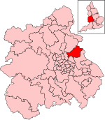
Whittington is a village and civil parish which lies approximately 3 miles south east of Lichfield, in the Lichfield district of Staffordshire, England. According to the 2001 census it had a population of 2,591, increasing to 2,603 at the 2011 Census. The parish council is a joint one with Fisherwick. The Coventry Canal borders the village to the north and east.
Excerpt from the Wikipedia article Whittington, Staffordshire (License: CC BY-SA 3.0, Authors, Images).Whittington, Staffordshire
Fisherwick Road, Lichfield Whittington
Geographical coordinates (GPS) Address Nearby Places Show on map
Geographical coordinates (GPS)
| Latitude | Longitude |
|---|---|
| N 52.67 ° | E -1.76 ° |
Address
Fisherwick Road
WS14 9LH Lichfield, Whittington
England, United Kingdom
Open on Google Maps


