place

Douglas, Michigan

1851 establishments in MichiganCities in Allegan County, MichiganMichigan populated places on Lake MichiganPopulated places established in 1851
Allegan County Michigan Incorporated and Unincorporated areas Douglas Highlighted

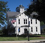
Douglas (officially known as the City of the Village of Douglas) is a city in Allegan County in the U.S. state of Michigan. The population was 1,378 at the 2020 census. The city is surrounded by Saugatuck Township and the city of Saugatuck is adjacent on the north. On December 13, 2004, residents voted to adopt a charter changing the status of the village into a city form of government. Under Michigan law, cities are independent entities whereas villages are part of the township. The official name is City of the Village of Douglas.

Excerpt from the Wikipedia article Douglas, Michigan (License: CC BY-SA 3.0, Authors, Images).

Douglas, Michigan
West Center Street,

Geographical coordinates (GPS) Address Phone number Nearby Places
placeShow on map

Wikipedia: Douglas, MichiganContinue reading on Wikipedia

Geographical coordinates (GPS)

Latitude Longitude
N 42.642777777778 ° E -86.206111111111 °
placeShow on map

Address

Lake Vista SuperValu

West Center Street 237
49406
Michigan, United States
mapOpen on Google Maps

Phone number

call+12698572443

Allegan County Michigan Incorporated and Unincorporated areas Douglas Highlighted
Share experience

Nearby Places

Saugatuck Gap Filler Radar Annex

The Saugatuck Gap Filler Annex (ADC ID: P-67C, NORAD ID: Z-67C, Z-34G) is a decommissioned radar installation that once served in the vast Cold War era Semi-Automatic Ground Environment (SAGE) air defense system. Of the hundreds of SAGE radars, Saugatuck's is one of, perhaps, two that remain nearly completely intact. Located immediately across the Kalamazoo River from Saugatuck, Michigan, at the top of Mount Baldhead, a 230-foot dune on the shore of Lake Michigan, the annex was positioned to fill gaps in the coverage of long-range "heavy" radars sited further inland. The heavy radars searched for attacking Soviet bombers but were unable to detect aircraft flying low to the west of the dunes along Lake Michigan. Saugatuck's original AN/FPS-14 radar was commissioned in mid-1958 and operated until it was replaced with a more capable AN/FPS-18 in 1963. The FPS-18 radar served continuously until the site was decommissioned early in 1968. The city of Saugatuck purchased the building, tower, and radar equipment from the Air Force in 1969. Today, the installation appears very much as it did when operational with virtually all of the Cold War-era electronic equipment still in place. The Saugatuck Gap Filler Annex was listed on the National Register of Historic Places in 2022, and efforts are underway by a work group commissioned by the city of Saugatuck to stabilize the site and secure funding for further preservation and restoration.