Schroon River
AdirondacksEssex County, New York geography stubsNew York (state) river stubsRivers of Essex County, New YorkRivers of New York (state) ... and 3 more
Rivers of Warren County, New YorkTributaries of the Hudson RiverWarren County, New York geography stubs

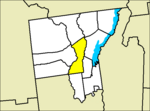
The Schroon River ( SKROON) is a 67.7-mile-long (109.0 km) tributary of the Hudson River in the southern Adirondack Mountains of New York, beginning at the confluence of Crowfoot Brook and New Pond Brook near Underwood, and terminating at the Hudson in Warrensburg. Its watershed is entirely within the Adirondack Park. The river runs through the towns of North Hudson, Schroon, Chester, Bolton, and Warrensburg. Interstate 87, the Adirondack Northway, follows the Schroon River valley from Warrensburg to Underwood. U.S. Route 9 takes a parallel course from Warrensburg to Schroon Lake, then follows the river through Underwood.
Excerpt from the Wikipedia article Schroon River (License: CC BY-SA 3.0, Authors, Images).Schroon River
River Street,
Geographical coordinates (GPS) Address Nearby Places Show on map
 Continue reading on Wikipedia
 Geographical coordinates (GPS)
| Latitude | Longitude |
|---|---|
| N 43.480555555556 ° | E -73.813888888889 ° |
Address
River Street
River Street
12885
New York, United States
Open on Google Maps