Proastio, Patras
Neighborhoods in Patras
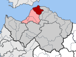
Proastio (Greek: Προάστιο or Προάστειο, meaning "suburb"; before 1928 it was named Bozaitika, Μποζαΐτικα in Greek) is a neighbourhood in the northern part of the city of Patras, 6 km from the city centre. The Greek National Road 8 (Corinth - Patras) and the OSE Corinth - Patras railway line pass through the neighbourhood. The river Charadros flows 1 km north. The municipal boundary with Rio is also to the north.
Excerpt from the Wikipedia article Proastio, Patras (License: CC BY-SA 3.0, Authors).Proastio, Patras
Simeonos, Municipality of Patras 1st Community of Patras - Arctic Sector (Municipal Unit of Patras)
Geographical coordinates (GPS) Address Nearby Places Show on map
 Continue reading on Wikipedia
 Geographical coordinates (GPS)
| Latitude | Longitude |
|---|---|
| N 38.2802 ° | E 21.7694 ° |
Address
Συμεώνος
Simeonos
264 43 Municipality of Patras, 1st Community of Patras - Arctic Sector (Municipal Unit of Patras)
Peloponnese, Western Greece and the Ionian, Greece
Open on Google Maps