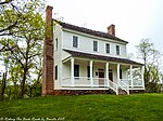
Round Peak, North Carolina
Surry County, North Carolina geography stubsUnincorporated communities in North CarolinaUnincorporated communities in Surry County, North CarolinaUse mdy dates from July 2023
Round Peak is an unincorporated community in Surry County, North Carolina, United States, near Mount Airy with an elevation of 1,280 feet. It is located in the southern Appalachian Mountains and gives its name to the Round Peak style of old-time music practiced in the area.The community of Round Peak is named for the nearby summit of Round Peak which has an elevation of 2,094 feet (Powell 1968, p. 427). Popular attractions include the Round Peak Vineyards, part of the Yadkin Valley wine region.
Excerpt from the Wikipedia article Round Peak, North Carolina (License: CC BY-SA 3.0, Authors).Round Peak, North Carolina
Majestic Lane,
Geographical coordinates (GPS) Address Nearby Places Show on map
Geographical coordinates (GPS)
| Latitude | Longitude |
|---|---|
| N 36.513 ° | E -80.787 ° |
Address
Majestic Lane 154
27024
North Carolina, United States
Open on Google Maps


