place

Brockworth

Borough of TewkesburyUse British English from March 2015Villages in Gloucestershire
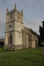
St George's Church, Brockworth. geograph.org.uk 566900

Brockworth is a village and parish in the Borough of Tewkesbury, Gloucestershire, England, situated on the old Roman road that connects the City of Gloucester with Barnwood. It is located 4 miles (6.5 km) southeast of central Gloucester, 6 miles (9.5 km) southwest of Cheltenham and 11.5 miles (18.5 km) north of Stroud. The population taken at the 2011 census was 7,387. The population increased to 9,422 at the 2021 Census.Since the mid-20th century, Brockworth has been known locally for the annual rolling of Double Gloucester cheese down Cooper's Hill. During World War II the nearby village of Hucclecote at the Gloster Aircraft Company produced the famous Hawker Hurricane fighter, and following the war it gained renewed fame for producing several notable aircraft, including Britain's first jet aircraft, which was test flown here. Brockworth is also the birthplace of actor, comedian and writer Simon Pegg.

Excerpt from the Wikipedia article Brockworth (License: CC BY-SA 3.0, Authors, Images).

Brockworth
Mill Lane, Gloucester Brockworth

Geographical coordinates (GPS) Address Phone number Website Nearby Places
placeShow on map

Wikipedia: BrockworthContinue reading on Wikipedia

Geographical coordinates (GPS)

Latitude Longitude
N 51.85 ° E -2.15 °
placeShow on map

Address

Henley Bank High School

Mill Lane
GL3 4QF Gloucester, Brockworth
England, United Kingdom
mapOpen on Google Maps

Phone number

call+441452863372

Website
henleybankhighschool.co.uk

linkVisit website

St George's Church, Brockworth. geograph.org.uk 566900
Share experience

Nearby Places

Gloucestershire
Gloucestershire

Gloucestershire ( (listen) (listen) abbreviated Glos) is a county in South West England. The county comprises part of the Cotswold Hills, part of the flat fertile valley of the River Severn and the entire Forest of Dean. The county town is the city of Gloucester and other principal towns and villages include Cheltenham, Cirencester, Kingswood, Bradley Stoke, Stroud, Thornbury, Yate, Tewkesbury, Bishop's Cleeve, Churchdown, Brockworth, Winchcombe, Dursley, Cam, Berkeley, Wotton-under-Edge, Tetbury, Moreton-in-Marsh, Fairford, Lechlade, Northleach, Stow-on-the-Wold, Chipping Campden, Bourton-on-the-Water, Stonehouse, Nailsworth, Minchinhampton, Painswick, Winterbourne, Frampton Cotterell, Coleford, Cinderford, Lydney and Rodborough and Cainscross that are within Stroud's urban area. Gloucestershire borders Herefordshire to the north-west, Worcestershire to the north, Warwickshire to the north-east, Oxfordshire to the east, Wiltshire to the south, Bristol and Somerset to the south-west, and the Welsh county of Monmouthshire to the west. The current Gloucestershire County Council area does not have the same geographical boundaries as the historic county. Some northern parts of the county, including Long Marston and Welford-on-Avon, were transferred to Warwickshire in 1931. Following the Local Government Act 1972, some southern parts of the county were transferred for administrative purposes to the new county of Avon, which ceased to exist on 1 April 1996. After 1996, the city of Bristol and South Gloucestershire became separate unitary authorities.