place

Fitling

East Riding of Yorkshire geography stubsFormer civil parishes in the East Riding of YorkshireHoldernessOpenDomesdayUse British English from July 2014
Villages in the East Riding of Yorkshire
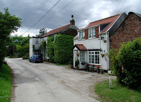
Fitling Lane
Fitling Lane

Fitling is a hamlet in the civil parish of East Garton, in the East Riding of Yorkshire, England, in an area known as Holderness. It is situated approximately 7 miles (11 km) north-west of Withernsea town centre. It lies 1 mile (1.6 km) west of the B1242 road. Fitling was formerly a township in the parish of Humbleton, in 1866 Fitling became a civil parish, on 1 April 1935 the parish was abolished to form East Garton. In 1931 the parish had a population of 85.In 1823 parish inhabitants numbered 119. Occupations included ten farmers and a shoemaker.

Excerpt from the Wikipedia article Fitling (License: CC BY-SA 3.0, Authors, Images).

Fitling
Westfield Lane,

Geographical coordinates (GPS) Address Nearby Places
placeShow on map

Wikipedia: FitlingContinue reading on Wikipedia

Geographical coordinates (GPS)

Latitude Longitude
N 53.786725 ° E -0.100824 °
placeShow on map

Address

Westfield Lane

Westfield Lane
HU12 9AH , East Garton
England, United Kingdom
mapOpen on Google Maps

Fitling Lane
Fitling Lane
Share experience

Nearby Places

Danthorpe
Danthorpe

Danthorpe is a hamlet in the civil parish of Elstronwick and the East Riding of Yorkshire, England, and in an area known as Holderness. The hamlet is approximately 4 miles (6 km) north-east of the town of Hedon, 1 mile (1.6 km) north of the village of Burton Pidsea, and 14 miles (23 km) south-east from the county town of Beverley. Danthorpe is centred on Southfield Lane, the road running from Burton Pidsea to Humbleton, and just south of its junction with Back Lane running 1 mile west to the parish village of Elstronwick. Danthorpe was formerly a township in the parish of Humbleton, in 1866 Danthorpe became a civil parish, on 1 April 1935 the parish was abolished and merged with Elstronwick. In 1931 the parish had a population of 52.Danthorpe is listed in the Domesday Book as 'Danetorp', in the Hundred of Holderness, and was of 5.2 geld units—taxable units assessed by hide area—and contained one ploughland, 3.8 households, and one smallholder. In 1066 the lordship was held by the Canons of Beverley St John, who held thirty-three manors in the east of Yorkshire under the overlordship of Ealdred, Archbishop of York. This lordship was retained by the Beverley canons in 1086, under the following archbishop of York, Thomas of Bayeux, who was also Tenant-in-chief to king William I.In 1823, Baines recorded that Danthorpe was in the parish of Humbleton, and the wapentake and the liberty of Holderness, and had a population of 56 including a corn miller and three farmers.At the east of Danthorpe is the farm of the Grade II listed Danthorpe Hall. The hall dates to the late 17th century, with 18th- and 19th-century wing additions, and is built of red brick with pebbledash rendering.

Elstronwick
Elstronwick

Elstronwick is a village and civil parish in the East Riding of Yorkshire, England, in an area known as Holderness. It is situated approximately 3.5 miles (6 km) north-east of the town of Hedon and 1.5 miles (2.4 km) north-west of the village of Burton Pidsea. The civil parish is formed by the villages of Elstronwick and Lelley together with the hamlet of Danthorpe. According to the 2011 UK census, Elstronwick parish had a population of 298, an increase on the 2001 UK census figure of 287.The parish church of St Lawrence on Front Lane is designated a Grade II listed building and is now recorded in the National Heritage List for England, maintained by Historic England. There is also a chapel. A further Grade II listed building is Elstronwick Hall.Village amenities include a small playing field. In 1823 Baines's History, Directory and Gazetteer of the County of York gave Elstronwick's name as 'Elsternwick'. The village at the time was in the parish of Humbleton and in the Wapentake of Holderness. There was a chapel of ease, "apparently of great antiquity", and a free school. The village had a population of 154, with occupations including six farmers, two wheelwrights, a blacksmith, a shoemaker, and the licensed victualler of The Crown and Anchor public house. Also directory-listed was a school mistress, two gentlemen and a foreman. Once a week a carrier operated between the village and Hull. The Crown and Anchor closed and was converted into cottages c. 2015.