place

Ryme Intrinseca

Liberties of DorsetVillages in Dorset
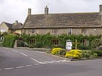
Cottage at Ryme Intrinseca geograph.org.uk 405864

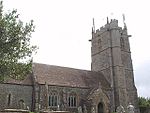
Ryme Intrinseca ( ) is a village and civil parish in northwest Dorset, England, 4 miles (6.4 km) south of Yeovil and 1 mile (1.6 km) west of Yetminster. It is sited on a low ridge of cornbrash limestone on the edge of the Blackmore Vale. The Intrinseca part of the name derives from the existence of the manors of Long Bredy and Langton Herring in the south of the county which also went by the name Ryme; that Ryme was known as Ryme Extrinsica but the name has long fallen out of use. In the 2011 census the parish had a population of 115.The church at Ryme Intrinseca, which dates back to the 13th century, is dedicated to St. Hippolytus and there are only two churches dedicated as such in England: cf. St Ippolyts, a village on the southern edge of Hitchin in Hertfordshire. The chancel and nave of the church are basically from the 13th century, but architecturally the most interesting features lie in the unusual 17th-century work which includes the east window and most of the windows in the nave, (including the little trefoil placed high to light the pulpit). Also from the early 17th century is the tower, with its intricate profile caused by the projecting stairway. There is an alms dish in the church which was lost in 1873 and found its way back to Dorset from Bideford in Devon in 1938. Ryme once constituted a separate liberty, containing only the parish itself.

Excerpt from the Wikipedia article Ryme Intrinseca (License: CC BY-SA 3.0, Authors, Images).

Ryme Intrinseca
Ryme Road,

Geographical coordinates (GPS) Address Nearby Places
placeShow on map

Wikipedia: Ryme IntrinsecaContinue reading on Wikipedia

Geographical coordinates (GPS)

Latitude Longitude
N 50.8959 ° E -2.5965 °
placeShow on map

Address

Ryme Road

Ryme Road
DT9 6JX , Ryme Intrinseca
England, United Kingdom
mapOpen on Google Maps

Cottage at Ryme Intrinseca geograph.org.uk 405864
Share experience

Nearby Places

Melbury Osmond
Melbury Osmond

Melbury Osmond is a village and civil parish in the county of Dorset in southern England. It lies approximately 7 miles (11 km) south of the Somerset town of Yeovil. The underlying geology is Cornbrash limestone, with adjacent Oxford clay. Within the clay can be found deposits of stone which can take on a very high polish, earning them the name "Melbury marble". The village is mentioned in the Domesday Book as a possession of the Arundell family, and remained so until the 19th century. The parish church, St. Osmund's, was totally rebuilt in 1745 and restored in 1888, although it has registers dating back to 1550. In the 2011 census the parish had a population of 199.The major part of Melbury Osmond village lies on a cul-de-sac lane which from the church descends past cottages to a stream and ford. The attractive appearance of the village has been noted by commentators: it has been described as "a calendarsmith's dream of thatched cottages" and in 1906 Sir Frederick Treves wrote that it was "the most charming village in these Western backwoods".In its history the village has been involved in the trade of plated buckles and horn buttons, and the manufacture of dowlas. During the 19th century, the village was home to the Dorset Ooser, a wooden mask brought out during "Rough Music" ceremonies.There are 34 listed buildings and structures within the parish, including the Grade II* Old Rectory and the Grade I parish church.Thomas Hardy's mother lived in Melbury Osmond as a child, and she was married in the church. The village appears as "Little Hintock" in Hardy's novel The Woodlanders, in which the heroine's name is "Grace Melbury". Hardy also incorporated a legend about the Duke of Monmouth taking refuge in one of the village's cottages into his short story "The Duke's Reappearance".