Agoura Hills, California
1982 establishments in CaliforniaAgoura Hills, CaliforniaCities in Los Angeles County, CaliforniaConejo ValleyIncorporated cities and towns in California ... and 6 more
Neighborhoods in Agoura Hills, CaliforniaPages including recorded pronunciationsPopulated places established in 1982Populated places in the Santa Monica MountainsSimi HillsUse mdy dates from March 2015

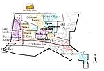
Agoura Hills ( ) is a city in the Santa Monica Mountains region of Los Angeles County, California, United States. Its population was 20,330 at the 2010 census, which decreased to 20,299 in 2020. It is in the eastern Conejo Valley between the Simi Hills and the Santa Monica Mountains. The city is in western Los Angeles County and is bordered to the north by Bell Canyon and Ventura County. It is 35 miles (56 km) northwest of Downtown Los Angeles and less than 10 miles (16 km) west of the Los Angeles city limits at Woodland Hills. Agoura Hills and unincorporated Agoura sit next to Calabasas, Oak Park, and Westlake Village.
Excerpt from the Wikipedia article Agoura Hills, California (License: CC BY-SA 3.0, Authors, Images).Agoura Hills, California
Quail Run Drive,
Geographical coordinates (GPS) Address Nearby Places Show on map
Geographical coordinates (GPS)
| Latitude | Longitude |
|---|---|
| N 34.153333333333 ° | E -118.76166666667 ° |
Address
Quail Run Drive 29166
91301
California, United States
Open on Google Maps


