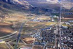
Keene, California
1876 establishments in CaliforniaCensus-designated places in CaliforniaCensus-designated places in Kern County, CaliforniaPopulated places established in 1876Tehachapi Mountains ... and 1 more
Use mdy dates from July 2023

Keene (formerly, Wells) is a census-designated place (CDP) in Kern County, California in the foothills of the Tehachapi Mountains at the southern extreme of the San Joaquin Valley. Keene is located 8.5 miles (14 km) northwest of Tehachapi, at an elevation of 2,602 feet (793 m). The population was 469 at the 2020 census, up from 431 at the 2010 census. The headquarters of the United Farm Workers (UFW), a national farmworkers organization organized and led by Cesar Chavez, is located in Keene, and is sometimes referred to as "Nuestra Señora Reina de La Paz" ("Our Lady Queen of Peace"). Keene is located in the greater Tehachapi area.
Excerpt from the Wikipedia article Keene, California (License: CC BY-SA 3.0, Authors, Images).Keene, California
Woodford-Tehachapi Road,
Geographical coordinates (GPS) Address Nearby Places Show on map
Geographical coordinates (GPS)
| Latitude | Longitude |
|---|---|
| N 35.223611111111 ° | E -118.56222222222 ° |
Address
Woodford-Tehachapi Road 30038
93531
California, United States
Open on Google Maps


