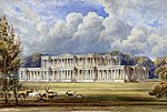
Silverton is a large village and civil parish, about 8 miles (13 km) north of Exeter, in the English county of Devon. It is one of the oldest villages in Devon and dates from the first years of the Saxon occupation.It has been suggested that the medieval manor of Burn, within the modern parish of Silverton, may be the estate listed as Mylenburnan (Mill-on-the-Burn or Burn Mill) in the will of King Alfred the Great of 899, now in the British Library, in which it was left to his youngest son Athelweard (c. 880-922).
In the year 2001, its population was 1,905, recounted to 1,494 at the United Kingdom Census 2011. The electoral ward with the same name had a population of 1,875 at the above census. The parish has two pubs: The Lamb and The Silverton Inn. The church, dating back to the fourteenth century, is dedicated to St Mary. It has a full set of bells that are rung regularly. Inside, the pews have doors at the end of each row which is unusual in this area. The village also has a further two churches - an Evangelical and a Methodist church; both are popular with social and youth clubs.
The village is on the "old" road from Exeter to Tiverton and as such was once a busy thriving place. Now it has become a dormitory for people working in Exeter although there are still a number of original families living in the village. A post office, a small supermarket (Spar) and a hairdresser offer most necessities for the residents.
The main feature of the village is the giant oak tree which is over 1,000 years old.On the first Saturday of each August, the village holds the Silverton Street Market, which is popular amongst both local people and many from across Devon and the South West. There are stalls selling local goods and crafts, as well as entertainment and children's activities organised throughout the day, and the tug-of-war always ends the day on a high.
Silverton is represented on Mid Devon District Council by Liberal Democratic Party Councillor Josh Wright (Village Ward) and by Conservative Councillor Rhys Roberts (North Ward).
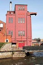
The Bristol and Exeter Railway opened a Station at Silverton in 1867, it closed to passengers on 5 October 1964 and freight 3 May 1965, but a private siding serving a paper mill, which had been opened on 26 July 1894, survived until the 31 August 1967. The Station Master from its opening until 1894 was one Roger Langdon (1825-1894), a noted amateur astronomer. Following the partial solar eclipse of 22 December 1870 Langdon altered his telescope to view a solar prominence. He also observed the planet Venus including the transit of 1882. A summary of his life was published by Patrick Moore.


