place

District of Columbia statistical areas

AC with 0 elementsUnited States statistical areasWashington, D.C.-related lists
Map of Washington Baltimore Arlington CSA, 2012

The United States District of Columbia (Washington, D.C.) is the primary city of two statistical areas that have been delineated by the Office of Management and Budget (OMB). On March 6, 2020, the OMB delineated the Washington-Arlington-Alexandria, DC-VA-MD-WV Metropolitan Statistical Area and the more extensive Washington-Baltimore-Arlington, DC-MD-VA-WV-PA Combined Statistical Area.

Excerpt from the Wikipedia article District of Columbia statistical areas (License: CC BY-SA 3.0, Authors, Images).

District of Columbia statistical areas
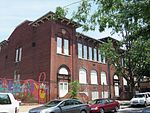
3rd Street Northwest, Washington

Geographical coordinates (GPS) Address Nearby Places
placeShow on map

Wikipedia: District of Columbia statistical areasContinue reading on Wikipedia

Geographical coordinates (GPS)

Latitude Longitude
N 38.9101 ° E -77.0147 °
placeShow on map

Address

3rd Street Northwest 1513
20001 Washington
District of Columbia, United States
mapOpen on Google Maps

Map of Washington Baltimore Arlington CSA, 2012
Share experience

Nearby Places

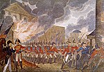
Burning of Washington

The Burning of Washington was a British invasion of Washington City (now Washington, D.C.), the capital of the United States, during the Chesapeake Campaign of the War of 1812. It is the only time since the American Revolutionary War that a foreign power has captured and occupied the capital of the United States. Following the defeat of American forces at the Battle of Bladensburg on August 24, 1814, a British force led by Major General Robert Ross marched to Washington. That night, British forces set fire to multiple government and military buildings, including the White House (then called the Presidential Mansion), the Capitol building, as well as other facilities of the U.S. government. The attack was in part a retaliation for American destruction in Upper Canada: U.S. forces had burned and looted its capital the previous year and then had burned buildings in Port Dover. Less than a day after the attack began, a heavy thunderstorm—possibly a hurricane—and a tornado extinguished the fires. The occupation of Washington lasted for roughly 26 hours. President James Madison, military officials, and his government evacuated and were able to find refuge for the night in Brookeville, a small town in Montgomery County, Maryland; President Madison spent the night in the house of Caleb Bentley, a Quaker who lived and worked in Brookeville. Bentley's house, known today as the Madison House, still exists. Following the storm, the British returned to their ships, many of which required repairs due to the storm.