Leeds Outer Ring Road

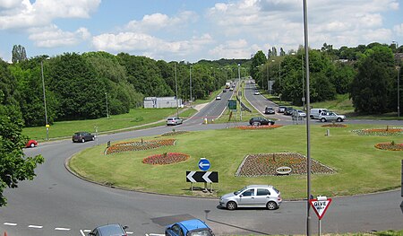
The Leeds Outer Ring Road is a main road that runs around most of the perimeter of the city of Leeds, West Yorkshire, England. The ring road is approximately 29 miles (45 km) and consists of single and dual carriageways. The road is not a loop and so is not a true ring road, although it is designated as such. The road begins in Belle Isle and ends in Thorpe Park, Leeds at junction 46 of the M1 motorway. It begins in Belle Isle as an un-numbered road and goes through to Beeston. It is then designated the A6110 between Beeston and Bramley a dual carriageway, before running concurrently with the Stanningley By-Pass A647 also a dual carriageway but with grade separated junctions. For the rest of the way between Farsley and Thorpe Park the road is the A6120 and it is a mixture of single and dual carriageway. The ring road ends at Junction 45 of the M1.
Excerpt from the Wikipedia article Leeds Outer Ring Road (License: CC BY-SA 3.0, Authors, Images).Leeds Outer Ring Road
Ring Road Meanwood, Leeds Moor Allerton
Geographical coordinates (GPS) Address Nearby Places Show on map
Geographical coordinates (GPS)
| Latitude | Longitude |
|---|---|
| N 53.8429 ° | E -1.5702 ° |
Address
Ring Road Meanwood
Ring Road Meanwood
LS16 8HG Leeds, Moor Allerton
England, United Kingdom
Open on Google Maps


