place

Diamond Point Airport

Airports in Washington (state)Pages with non-numeric formatnum argumentsTransportation buildings and structures in Clallam County, WashingtonWashington (state) building and structure stubsWashington (state) transportation stubs
Western United States airport stubs

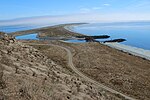
Diamond Point Airport is a private community airport located on the northeast corner of Miller Peninsula in Clallam County, Washington, 8 mi (13 km) east of Sequim. It opened in August 1965.Runway 11/29 is paved (asphalt) and has a length of 2,335 ft × 24 ft (712 m × 7 m), with a grass strip on the north side. Traffic pattern is to the north over the water. Runway lighting is on from dusk to dawn. Deer on the runway are common.See 2WA1.org for airport information, procedures, and photos.

Excerpt from the Wikipedia article Diamond Point Airport (License: CC BY-SA 3.0, Authors).

Diamond Point Airport
Airport Way,

Geographical coordinates (GPS) Address External links Nearby Places
placeShow on map

Wikipedia: Diamond Point AirportContinue reading on Wikipedia

Geographical coordinates (GPS)

Latitude Longitude
N 48.0925 ° E -122.92861111111 °
placeShow on map

Address

Diamond Point Airstrip

Airport Way

Washington, United States
mapOpen on Google Maps

linkWikiData (Q5270892)
linkOpenStreetMap (369033886)

Share experience

Nearby Places

Protection Island (Washington)

Protection Island is an island located in the Strait of Juan de Fuca just north of Discovery Bay in northeastern Jefferson County, Washington, United States. The island has a land area of 379 acres (153 ha). It is a federally protected National Wildlife Refuge; boats are not permitted within 200 yards (180 m) for the safety and health of wildlife on and near the shores. There is only one individual still living on the island not associated with the government. Marty Bluewater has lifetime use of his inholding cabin on the island's southern bluffs. The island also houses a caretaker, a volunteer hired by the United States Fish and Wildlife Service, to watch over the island and take care of its many inhabitants. Boat trips from nearby Port Townsend, Washington provide ecotourism visits for viewing wildlife from the adjacent waters. Spanish explorers were the first Europeans to find the island. In 1790 it was given the name Isla de Carrasco, in honor of Juan Carrasco. It was given its present name by George Vancouver in 1792.Protection Island National Wildlife Refuge was designated in 1982 to protect the entire island and its coast. Approximately 70 percent of the nesting seabird population of Puget Sound and the Strait of Juan de Fuca nest on the island, which includes one of the largest nesting colonies of rhinoceros auklets in the world and the largest nesting colony of glaucous-winged gulls in Washington. The island contains one of the last two nesting colonies of tufted puffins in the Puget Sound area. It is on the flyway for many migrating birds. Seals (harbor and elephant), sea lions, orcas, and other cetaceans are often seen nearby. About 1,000 harbor seals depend upon the island for a pupping and rest area.The refuge is closed to visitation to protect the fragile habitat. Visitors may view the island by boat; a 200-yard off-shore buffer is enforced to ensure adult birds are not flushed from their nests. The waters surrounding the North Olympic Peninsula support five additional refuges: Flattery Rocks, Quillayute Needles, Copalis, Dungeness, and San Juan Islands. Protection Island is managed as part of the Washington Maritime National Wildlife Refuge Complex.