place

Cirencester College

1991 establishments in EnglandCirencesterEducational institutions established in 1991Further education colleges in GloucestershireLearning and Skills Beacons
United Kingdom university stubsUse British English from September 2013
Cirencester College Logo

Cirencester College is a sixth form college based in the town of Cirencester in the South Cotswolds. It is a specialist sixth form provider serving communities in Gloucestershire, South Gloucestershire, Wiltshire and Oxfordshire. Cirencester College offers a wide choice of qualifications including A-levels, the new T-levels In addition to vocational training, the college has a good track-record of sending students on to higher education at a range of universities, apprenticeships and straight into employment.

Excerpt from the Wikipedia article Cirencester College (License: CC BY-SA 3.0, Authors, Images).

Cirencester College
Stroud Road, Cotswold District

Geographical coordinates (GPS) Address Phone number Website External links Nearby Places
placeShow on map

Wikipedia: Cirencester CollegeContinue reading on Wikipedia

Geographical coordinates (GPS)

Latitude Longitude
N 51.7125 ° E -1.9861111111111 °
placeShow on map

Address

Cirencester College

Stroud Road
GL7 1XA Cotswold District
England, United Kingdom
mapOpen on Google Maps

Phone number

call+441285640994

Website
cirencester.ac.uk

linkVisit website

linkWikiData (Q5121865)
linkOpenStreetMap (391734020)

Cirencester College Logo
Share experience

Nearby Places

Cirencester Amphitheatre

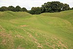
Cirencester Amphitheatre was a Roman amphitheatre in Cirencester, Gloucestershire, England. Its remains are scheduled as an ancient monument.Archaeological digs have uncovered the earthworks, revealing the outline of the construction, which is still visible, with the banking reaching 25 feet from the bottom of the arena. The arena itself is approximately 150 feet (46 m) by 135 feet (41 m). Roman artefacts including coins and pottery have been discovered on the site. It is estimated that it was constructed towards the beginning of the 2nd century. In Roman Britain, Cirencester was known as Corinium Dobunnorum, and was the second biggest town in Britannia, after Londinium (London). This amphitheatre is also the second largest, which indicates the significance of the location in Roman times. Although only slightly larger in diameter than the amphitheatre in Silchester, it has much higher sides. The earthworks show evidence of tiered wooden seats for around 8000 people, placed upon terraces made of stone, although a timber-only structure may have existed before the 2nd century. There are two entrances, at the north-east and south-west ends of the stadium.During the 5th century, when the Western Roman Empire was under attack and soldiers returned to Rome to defend it, the amphitheatre was fortified to defend against the invading Saxons. Wooden structures were erected within the arena, placed in postholes, and the north-east entrance was partly blocked.Unlike other amphitheatres, it is aligned in parallel to the streets of the town.It has also been referred to as the 'Bull Ring', because the sport of bull-baiting used to take place there.In 2012, plans were announced by the Cirencester Town Council to improve access and signage at the site. Further plans for a visitor centre and car park followed in 2014.