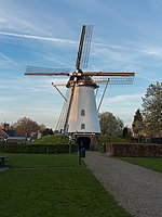
Elden, Netherlands
ArnhemFormer municipalities of GelderlandGelderland geography stubsPopulated places in Gelderland

Elden is a village in the Dutch province of Gelderland. It is located in the municipality of Arnhem, about 4 km southwest of the city centre. Elden was a separate municipality between 1813 and 1818, when it was merged with Elst. It became part of Arnhem in 1966.The village of Elden, on the south side of the Rhine, has now been completely surrounded by neighbourhoods of the city of Arnhem and is now an enclave. The village still has its own place name signs.
Excerpt from the Wikipedia article Elden, Netherlands (License: CC BY-SA 3.0, Authors, Images).Elden, Netherlands
Batavierenweg, Arnhem
Geographical coordinates (GPS) Address Nearby Places Show on map
Geographical coordinates (GPS)
| Latitude | Longitude |
|---|---|
| N 51.966666666667 ° | E 5.8833333333333 ° |
Address
Batavierenweg
Batavierenweg
6842 AA Arnhem
Gelderland, Netherlands
Open on Google Maps


