Ciudad Juárez

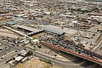
Ciudad Juárez (UK: thew-DAHD HWAR-ez, US: syoo-, Spanish: [sjuˈðað ˈxwaɾes] (listen); "Juárez City"), commonly referred to as just Juárez, is the most populous city in the Mexican state of Chihuahua. It was known until 1888 as El Paso del Norte ("The North Pass"). Juárez is the seat of the Juárez Municipality with an estimated population of 1.5 million people. It lies on the Rio Grande (Río Bravo del Norte) river, south of El Paso, Texas, United States. Together with the surrounding areas, the cities form El Paso–Juárez, the second largest binational metropolitan area on the Mexico–U.S. border (after San Diego–Tijuana), with a combined population of over 2.7 million people.Four international points of entry connect Ciudad Juárez and El Paso: the Bridge of the Americas, the Ysleta–Zaragoza International Bridge, the Paso del Norte Bridge, and the Stanton Street Bridge. Combined, these bridges allowed 22,958,472 crossings in 2008, making Ciudad Juárez a major point of entry and transportation into the U.S. for all of central northern Mexico. The city has a growing industrial center, which in large part is made up by more than 300 maquiladoras (assembly plants) located in and around the city. According to a 2007 New York Times article, Ciudad Juárez was "absorbing more new industrial real estate space than any other North American city". In 2008, fDi Magazine designated Ciudad Juárez "The City of the Future".
Excerpt from the Wikipedia article Ciudad Juárez (License: CC BY-SA 3.0, Authors, Images).Ciudad Juárez
Calle Vicente Guerrero, Ciudad Juárez
Geographical coordinates (GPS) Address Nearby Places Show on map
 Continue reading on Wikipedia
 Geographical coordinates (GPS)
| Latitude | Longitude |
|---|---|
| N 31.738580555556 ° | E -106.48701388889 ° |
Address
Fray García de San Francisco
Calle Vicente Guerrero
32001 Ciudad Juárez
Chihuahua, Mexico
Open on Google Maps