place

Kingsland station

1870 establishments in New JerseyFormer Delaware, Lackawanna and Western Railroad stationsLyndhurst, New JerseyNJ Transit Rail Operations stationsRailway stations in Bergen County, New Jersey
Railway stations in the United States opened in 1870
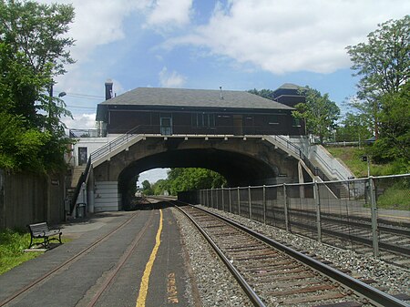
Kingsland Station facing Suffern bound

Kingsland is a railroad station on New Jersey Transit's Main Line. It is located under Ridge Road (Route 17) between New York and Valley Brook Avenues in Lyndhurst, New Jersey, and is one of two stations in Lyndhurst. The station is not staffed, and passengers use ticket vending machines (TVMs) located at street level to purchase tickets. The station is not handicapped-accessible. Originally part of the Delaware, Lackawanna and Western Railroad's Boonton Branch, the current Kingsland station was built in 1918.

Excerpt from the Wikipedia article Kingsland station (License: CC BY-SA 3.0, Authors, Images).

Kingsland station
Ridge Road,

Geographical coordinates (GPS) Address Nearby Places
placeShow on map

Wikipedia: Kingsland stationContinue reading on Wikipedia

Geographical coordinates (GPS)

Latitude Longitude
N 40.8101 ° E -74.1172 °
placeShow on map

Address

Kingsland Station

Ridge Road
07071
New Jersey, United States
mapOpen on Google Maps

Kingsland Station facing Suffern bound
Share experience

Nearby Places

Kingsland explosion
Kingsland explosion

The Kingsland explosion was an incident that took place during World War I at a munitions factory in Lyndhurst, New Jersey, United States, on January 11, 1917. An arbitration commission in 1931 determined that, "In the Kingsland Case the Commission finds upon the evidence that the fire was not caused by any German agent." Germany in 1953, paid $50 million ($510 million in 2023) in reparations to the United States. The Canadian Car and Foundry Company, based in Montreal, had signed large contracts with Russia and Britain for delivery of ammunition. An enormous factory was constructed in the New Jersey Meadowlands, which was then referred to as Kingsland. The company executives decided not to take any chances with security for their plant. They constructed a six-foot fence around the plant and hired security guards to conduct 24-hour patrols around the perimeter and screen each worker as they entered the plant. It was located on the site of Lyndhurst's present industrial park. A brick stack, believed to be the remaining part of the Foundry, is located in the area bounded by Valley Brook Avenue, Polito Avenue, and the office buildings on Wall Street West. On January 11, 1917, a fire started in Building 30 of the Canadian Car and Foundry Company at Kingsland in Bergen County, New Jersey. In 4 hours, probably 500,000 pieces of 76 mm (3") high explosive shells were discharged. The entire plant was destroyed. It was said to have been a spectacle more magnificent than the nearby 1916 explosion at Black Tom. From office buildings and tall apartments, people in New York City watched with amazement.

Yereance–Berry House

The Yereance–Berry House is a stone house built in the early 19th century in what is now Rutherford, in Bergen County, New Jersey, United States. It was placed on the National Register of Historic Places on January 10, 1983, and is currently home to the Meadowlands Museum. The house, 91 Crane Avenue at the corner of Meadow Road at the edge of the New Jersey Meadowlands, was inventoried by the Historic American Buildings Survey of the Library of Congress in 1938. At that time, the house was believed to have been built in 1804 and was known variously as the John W. Berry House or the Juria Jurianson House. The Yereance name came from the Yereance family, which at one time owned much of the property in the vicinity of the house. (There is a now-decommissioned Yereance Avenue two blocks north of the house.) However, Rutherford historian Frederick Bunker, in a 1979 report to the Meadowlands Museum, indicated that there was no evidence that a Yereance had ever owned the house. The Historic American Buildings Survey report (#6-468) said that the house was built by John W. Berry, a direct descendant of Major John Berry, who obtained land grants from Governor of New Jersey Philip Carteret in 1668. Berry had previously lived in Barbados and named his grants New Barbadoes, a name that remained in official use until 1826. Berrys Creek is also named after Major Berry. Bunker undertook a deed search of the property at the museum's request. While Bunker was unable to determine an actual construction date, he concluded that the house was likely built in 1818 by Brant Van Blarcom and his wife, the former Getty Van Riper, a daughter of the previous landowner Jacob Van Riper, who died on or about July 8, 1807. The Van Riper homestead was near the Passaic River, across a ridge from Meadow Road. Getty Van Blarcom received the property in 1817 as the result of an orphan's court proceeding that divided Jacob's property. William Berry, who was a direct descendant of John Berry, purchased the property in 1867 for his son Stephen and his wife Margaret. Stephen died in 1872 and Margaret died in 1882; the house was sold at auction in 1891 and was owned by Charles Smithson at the time of the Historic American Buildings Survey. By that time, a new kitchen had been built on the west side of the house, replacing a kitchen that was removed because it was in the right of way of Crane Avenue, which was officially extended east to Meadow Road in the 1930s. The house was purchased by the Rutherford Museum (now the Meadowlands Museum) in 1974, and the museum has maintained the house in addition to commissioning research on its provenance. In 1983, the house was re-surveyed for the Bergen County Stone House Survey (#0256-1), through which it achieved its placement on the National Register of Historic Places. The structure is composed of a brownstone foundation, with brownstone extending up to the water table and brick above it. The interior walls are brick, covered with plaster, and there are interior chimneys made of brick. The house has a gambrel roof.
Lyndhurst Draw
Lyndhurst Draw

The Lyndhurst Draw is a railroad bridge crossing the Passaic River between Clifton and Lyndhurst in northeastern New Jersey. Built in 1903, it is owned and operated by New Jersey Transit Rail Operations (NJT). The swing bridge is situated between the Lyndhurst and Delawanna stations of NJT's Main Line, 8.52 miles (13.71 km) from its origination point at Hoboken Terminal, and 11.7 miles (18.8 km) from the river's mouth at Newark Bay. Norfolk Southern Railway uses the bridge to access Croxton Yard to the east across the New Jersey Meadowlands. The bridge is required by federal regulations to open on 24-hour notice. It is listed on the New Jersey Register of Historic Places (ID#2950).The lower 17 miles (27 km) of the ninety-mile (140 km) long Passaic River downstream of the Dundee Dam is tidally influenced and navigable. Rail service across the river was originally oriented to bringing passengers and freight from the points west over the Hackensack Meadows to Bergen Hill, where tunnels and cuts provided access terminals on the Hudson River. The crossing of the river was developed under the auspices of the Delaware, Lackawanna, and Western Railroad (DL&W) as part of its Boonton Branch, which in 1960 merged with the Erie Railroad to form the Erie Lackawanna. In 1963, the Erie's Main Line south of Paterson through downtown Passaic was abandoned and service was shifted to the alignment over the Lyndhurst Draw and the Upper Hack Lift. Operations were later taken over by Conrail under contract with the New Jersey Department of Transportation, and in 1983 by NJT.