place

Gleneden Beach, Oregon

Lincoln County, Oregon geography stubsOregon CoastPopulated coastal places in OregonSeaside resorts in OregonUnincorporated communities in Lincoln County, Oregon
Unincorporated communities in OregonUse mdy dates from July 2023
Gleneden community hall

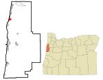
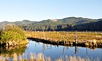
Gleneden Beach is an unincorporated community in Lincoln County, Oregon, United States. The area was originally platted in 1927. The town was named after its founding family members. It is located on the Oregon Coast five miles south of Lincoln City, just south of the Salishan Spa and Golf Resort, along U.S. Route 101, and north of Depoe Bay. There are 1,270 housing units in Gleneden Beach, and the median year in which these properties were built is 1977. Of the 537 occupied housing units in Gleneden Beach, 67.97% are owner-occupied, while 32.03% have renters living in them. There are 1,088 residents in Gleneden Beach, with a median age of 60. Of this, 45.96% are males and 54.04% are females. US-born citizens make up 94.39% of the resident pool in Gleneden Beach, while non-US-born citizens account for 1.38%. Additionally, 4.23% of the population is represented by non-citizens. A total of 853 people in Gleneden Beach currently live in the same house as they did last year.

Excerpt from the Wikipedia article Gleneden Beach, Oregon (License: CC BY-SA 3.0, Authors, Images).

Gleneden Beach, Oregon
Stevens Street,

Geographical coordinates (GPS) Address Nearby Places
placeShow on map

Wikipedia: Gleneden Beach, OregonContinue reading on Wikipedia

Geographical coordinates (GPS)

Latitude Longitude
N 44.881111111111 ° E -124.03416666667 °
placeShow on map

Address

Stevens Street 122
97388 , Gleneden Beach
Oregon, United States
mapOpen on Google Maps

Gleneden community hall
Share experience

Nearby Places

Siletz Bay National Wildlife Refuge

Siletz Bay National Wildlife Refuge is a U.S. National Wildlife Refuge on Oregon's coast. It is one of six National Wildlife Refuges (NWRs) comprising the Oregon Coast National Wildlife Refuge Complex. The refuge consists of several discontinuous tracts north and south of the Siletz River where it enters Siletz Bay south of Lincoln City. Previously closed to public use, excluding viewing from outside the refuge boundaries and during special events, the refuge now has a boat launch offering access to non-motorized boats. Alder Island Nature Trail caters to visitors on foot, opened in 2017, and is 0.85 miles (1.37 km) round trip.Siletz Bay NWR was established in 1991 primarily to return salt marsh to its natural state. Formerly it had been diked and ditched to create pasture for dairy cows. One segment of the refuge near Millport Slough, an arm of the lower Siletz River, consists of a 100-acre (40 ha) tidal marsh restored by the United States Fish and Wildlife Service, Ducks Unlimited, and the Confederated Tribes of Siletz. Together they breached 220 feet (67 m) of dikes, removed dikes totaling 9,300 feet (2,800 m), filled 1,200 feet (370 m) of ditches, and added woody debris to improve fish habitat. Salt-starched skeleton trees are visible along both sides of U.S. Route 101 (which runs through the refuge) from the time when the salt marsh was diked. Red-tailed hawks and bald eagles are often visible roosting on these snags. Abundant great blue herons and great egrets live nearby.

Kernville, Oregon
Kernville, Oregon

Kernville is an unincorporated community in Lincoln County, Oregon, United States. It is located near the intersection of U.S. Route 101 and Oregon Route 229, where the Siletz River enters Siletz Bay. There are two communities, known as "old" and "new" Kernville, in close proximity. Old Kernville is considered a ghost town.The "old" Kernville was the first European community in the area. It was started in 1896 by Daniel and John H. Kern, who operated a salmon cannery, Kern Brothers Packing Company, on the north bank of the Siletz River. At the time, the isolated location was only accessible by boat. In 1907 the cannery was sold and the new owners dismantled the building and rebuilt it on the south bank of the river. The sawmill, post office and original community of Kernville were also located on the more accessible south bank. Eventually the old town site, including what remained on the north side of the river, was abandoned. As of 1945, "new" Kernville was located about a mile downstream from its original location, near the old Oregon Coast Highway bridge. Since the rerouting of U.S. Route 101 and the completion of a new Siletz River Bridge in the 1980s, new Kernville is no longer on the main highway. Kernville post office ran intermittently from 1896-1968. After the decline in the fishing industry that started in the 1920s, the Kernville economy was increasingly based on logging. For a time, Kernville was the site of an important spruce mill, and during World War I it supplied wood for the airplanes being built by the U.S. Army Spruce Production Division for the war effort. At this time Kernville was known as "Millport".The 1971 film about a logging family in Oregon, Sometimes a Great Notion, based on the novel by Ken Kesey, was filmed in Kernville. A local Victorian house served as the set for the "Stamper House".