Ford, North Wiltshire
EngvarB from August 2019Villages in WiltshireWiltshire geography stubs

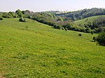
Ford is a small village in the north-west of Wiltshire, England. The village is on the A420 road, 4 miles west of Chippenham and 11 miles east of Bristol. Ford is the second largest village in the civil parish of North Wraxall, a collection of five settlements which includes Upper Wraxall, North Wraxall, The Shoe (also on the A420) and Mountain Bower. There is a pub called the White Hart, but no other shops. The Bybrook River flows through the village. A church of St John was designed by C.E. Ponting in 1896 and converted into a residence in 2001.
Excerpt from the Wikipedia article Ford, North Wiltshire (License: CC BY-SA 3.0, Authors, Images).Ford, North Wiltshire
A420,
Geographical coordinates (GPS) Address Website Nearby Places Show on map
Geographical coordinates (GPS)
| Latitude | Longitude |
|---|---|
| N 51.472 ° | E -2.23 ° |
Address
The White Hart Inn
A420
SN14 8RP
England, United Kingdom
Open on Google Maps


