Lake Columbia

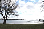
Lake Columbia is a man-made lake in Columbia Township in southern Jackson County in the U.S. state of Michigan. Originally formed as a mill pond in 1836, it was expanded to 840 acres (3.4 km2) in 1961. At its greatest extent, the lake is 2 and 1/4 miles long and 1 and 3/4 miles wide. It has approximately 14 miles (23 km) of shoreline and the water source to the lake is Goose Creek. The lake has an average depth of 18 feet (5.5 m). Lake Columbia is located 2 miles (3.2 km) west of Brooklyn, Michigan. The latitude for the lake is 42.0928 and the longitude is -84.3011 with an elevation of 988 ft (301 m) above sea level. Lake Columbia is one of the many lakes in Jackson County that is entirely private. Yearly membership dues in the Lake Columbia Property Owners Association are required by residents of the lake. The lake has a total of 16 private parks. It also has 14 named shores where residents reside. It is a boaters and fishers paradise for local residents of the lake. Lake Columbia is stocked annually with Walleye or Bluegill fish. The fish population continues to grow in Lake Columbia every year.
Excerpt from the Wikipedia article Lake Columbia (License: CC BY-SA 3.0, Authors, Images).Lake Columbia
Nottingham Drive, Columbia Township
Geographical coordinates (GPS) Address Nearby Places Show on map
Geographical coordinates (GPS)
| Latitude | Longitude |
|---|---|
| N 42.0928 ° | E -84.3011 ° |
Address
Nottingham Drive
Nottingham Drive
49230 Columbia Township
Michigan, United States
Open on Google Maps


