Acy, Louisiana
Baton Rouge metropolitan areaLouisiana geography stubsUnincorporated communities in Ascension Parish, LouisianaUnincorporated communities in LouisianaUse mdy dates from July 2023
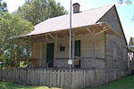
Acy is an unincorporated community in the southeastern part of Louisiana, United States. Acy is located approximately 24 miles (39 km) southeast of Baton Rouge and 45 miles (72 km) northwest of New Orleans on Louisiana Highway 22 in the parish of Ascension. The residents live along highways LA22, LA936, LA937, and many short parish side roads mostly named after current or past residents of the area. Acy consists of woodlands and pastures. Acy is a rural area located off a ridge surrounded by swamp lands. Its area is six miles (9.7 km) long and about one mile (1.6 km) wide.
Excerpt from the Wikipedia article Acy, Louisiana (License: CC BY-SA 3.0, Authors).Acy, Louisiana
LA 22,
Geographical coordinates (GPS) Address Nearby Places Show on map
 Continue reading on Wikipedia
 Geographical coordinates (GPS)
| Latitude | Longitude |
|---|---|
| N 30.218888888889 ° | E -90.820277777778 ° |
Address
LA 22 46532
70774
Louisiana, United States
Open on Google Maps