Low Worsall
Civil parishes in North YorkshireNorth Yorkshire geography stubsUse British English from April 2018Villages in North Yorkshire

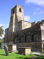
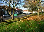
Low Worsall is a small village and civil parish in Hambleton district of North Yorkshire, England, near High Worsall and 3 miles (4.8 km) west of Yarm.In 1732, Richard and Thomas Peirse developed a port on the southern banks of the River Tees at Low Worsall, and named it Peirseburgh. The river was naviagable as far as Worsall at that time, and exports of lead would pass through Worsall to be loaded onto ships at Yarm. The brothers developed a port to capture road traffic and transfer it to and from ships.
Excerpt from the Wikipedia article Low Worsall (License: CC BY-SA 3.0, Authors, Images).Low Worsall
Village Road,
Geographical coordinates (GPS) Address Nearby Places Show on map
Geographical coordinates (GPS)
| Latitude | Longitude |
|---|---|
| N 54.48321 ° | E -1.39578 ° |
Address
Village Road
Village Road
TS15 9PL
England, United Kingdom
Open on Google Maps


