place

Watauga Lake

1948 establishments in TennesseeBodies of water of Carter County, TennesseeBodies of water of Johnson County, TennesseeCherokee National ForestProtected areas of Carter County, Tennessee
Protected areas of Johnson County, TennesseeReservoirs in TennesseeTennessee Valley AuthorityWatauga River
WataugaLake
WataugaLake

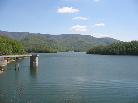
Watauga Lake, located east of Elizabethton, Tennessee, is the local name of the Watauga Reservoir created by the Tennessee Valley Authority (TVA) with the 1948 completion of the TVA Watauga Dam.The Cherokee National Forest surrounds both the Tennessee Valley Authority Watauga Reservoir and Wilbur Reservoir in an area of northeast Tennessee that TVA describes as being located "in some of the most beautiful country in the Tennessee River watershed".

Excerpt from the Wikipedia article Watauga Lake (License: CC BY-SA 3.0, Authors, Images).

Watauga Lake
Deer Run Road,

Geographical coordinates (GPS) Address Nearby Places
placeShow on map

Wikipedia: Watauga LakeContinue reading on Wikipedia

Geographical coordinates (GPS)

Latitude Longitude
N 36.333055555556 ° E -82.031944444444 °
placeShow on map

Address

Deer Run Road

Deer Run Road

Tennessee, United States
mapOpen on Google Maps

WataugaLake
WataugaLake
Share experience

Nearby Places

Wilbur Dam
Wilbur Dam

Wilbur Dam is a hydroelectric dam on the Watauga River in Carter County, in the U.S. state of Tennessee. It is one of two dams on the river owned and operated by the Tennessee Valley Authority. The dam impounds Wilbur Lake, which extends for about 3 miles (4.8 km) up the Watauga to the base of Watauga Dam. Wilbur Dam was completed in 1912 making it the second oldest dam in the TVA system behind Ocoee Dam No. 1. Wilbur Dam was one of the first major hydroelectric projects in Tennessee, and remains one of the oldest dams in the TVA system.Wilbur Dam is a concrete gravity overflow dam 77 feet (23 m) high and 375 feet (114 m) long, and has a generating capacity of 10,700 kilowatts. The dam's spillway has four radial gates with a combined discharge of 34,000 cubic feet per second (960 m3/s). The dam is located at just over 34 miles (55 km) above the mouth of the Watauga, a few miles upstream from Elizabethton, Tennessee. In 1907, the Doe River Light & Power Company began purchasing land rights for construction of Wilbur Dam, although the company struggled with finances and sold the project to the Watauga Power Company in 1910. Watauga Power completed the dam in just two years, and found a ready market for the dam's electricity at nearby Elizabethton. In 1927, the dam was purchased by the Tennessee Central Service Company, which changed its name to East Tennessee Light & Power Company two years later. The flood of August 1940 overtopped the dam and destroyed its powerhouse, and five years later, East Tennessee Light & Power sold its assets, including Wilbur Dam, to the Tennessee Valley Authority.Wilbur Dam was originally equipped with a flashboard-controlled spillway (similar to nearby Nolichucky Dam). In 1947, TVA outfitted the dam with a new gate-controlled spillway and raised it 5 feet (1.5 m) to accommodate the tailwaters of Watauga Dam, which was then nearing completion.