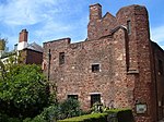
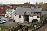
Exe Island

Exe Island was the early industrial area of Exeter, England, and was an area of marshland between the city walls and the River Exe, reclaimed by the construction of a series of leats, or artificial water courses, possibly from as early as the 10th century. The leats were dug because the bank area was very wet and benefitted from draining. The leats allowed for land reclamation. The Upper Leat, which still exists, created Exe Island, which eventually became a separate manor belonging to the Courtenays, Earls of Devon. The Courtenays took over the island after the Norman invasion, between 1180 and 1190. Robert Courtenay allowed Nicholas Gervaise to build a mill; many other mills were built for grinding corn and for the fulling of wool. The leats were used to drive the mill wheels.Exe Island had become an industrial area by the end of the 12th Century. Industries included tanneries, but archeologists later discovered that the working of horn and bronze had also been common. By the 16th century, cloth finishing was the most significant industry but that declined in the 1800s. By late in that century, iron foundries, corn mills and breweries were more common.Earlier, in 1549, King Edward granted Exe Island to Exeter, leading to the Prayer Book Rebellion, in favour of Protestant theology in an era when most people were still loyal to Catholicism. The rebellion was put down by Lord John Russell. By 1649, Exe had become the water source for Exeter. The wool industry became very successful after the Civil War making the fulling mills on Exe profitable. In 1778 "Exe Island was effectively cut in two by the new viaduct" although a tunnel under the New Bridge Street allowed for travel between the two sides.In the 1800s, gas works and foundries replaced many of the mills. The first school was built in 1873.
Excerpt from the Wikipedia article Exe Island (License: CC BY-SA 3.0, Authors, Images).Exe Island
Mission Court, Exeter St Thomas
Geographical coordinates (GPS) Address Nearby Places Show on map
Geographical coordinates (GPS)
| Latitude | Longitude |
|---|---|
| N 50.7197 ° | E -3.5366 ° |
Address
Mission Court 1
EX4 3BU Exeter, St Thomas
England, United Kingdom
Open on Google Maps


