place

Woodroffe North

Neighbourhoods in OttawaUse Canadian English from January 2023
Map 2 809x6671
Map 2 809x6671

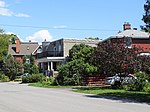
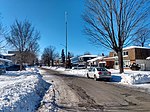
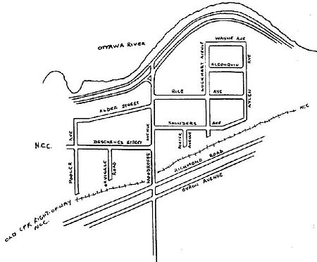
Woodroffe North (also known as just Woodroffe) is a neighbourhood in Bay Ward in the west end of Ottawa, Ontario, Canada. It is bounded on the south by Richmond Road on the west by the Sir John A. Macdonald Parkway, on the north by the Ottawa River and on the east by the northern prolongation of Sherbourne Avenue. Woodroffe North has also been referred to as a community within the neighbourhood of Westboro (also known as Westboro Village) which claims its western border to be Woodroffe Avenue. The Woodroffe North Community includes residents that live on streets West of Woodroffe Avenue. Originally the homes used to be cottages similar to those in Britannia. Most of the cottages were demolished and changed into houses. Lockhart Avenue is split up at Richmond Road and continues at Byron and ends at Saville Row in front of Carlingwood. The total population of the neighbourhood (2011 Census) is 3722.The area west of Orchard Avenue is known as Ambleside.

Excerpt from the Wikipedia article Woodroffe North (License: CC BY-SA 3.0, Authors, Images).

Woodroffe North
Rice Avenue, (Old) Ottawa

Geographical coordinates (GPS) Address Nearby Places
placeShow on map

Wikipedia: Woodroffe NorthContinue reading on Wikipedia

Geographical coordinates (GPS)

Latitude Longitude
N 45.37998 ° E -75.77578 °
placeShow on map

Address

Rice Avenue 2166
K2A 4A1 (Old) Ottawa
Ontario, Canada
mapOpen on Google Maps

Map 2 809x6671
Map 2 809x6671
Share experience

Nearby Places

Carlingwood
Carlingwood

Carlingwood is a neighbourhood in Bay Ward in the west end of Ottawa, Ontario, Canada. The neighbourhood is roughly bounded on the north by Richmond Road, on the east by Sherbourne Road, on the south by Carling Avenue and on the west by Woodroffe Avenue. This area corresponds to census tract 5050032.01, which had a population of 3,558 according to the Canada 2016 Census.The Carlingwood Shopping Centre was built in 1956 at the corner of Carling and Woodroffe. The surrounding neighbourhood would be built later in the decade. Somserset Towers and the Saville Apartments (then known as Saville Terrace) were built in the early 1960s, and Bromley Square was built in the early 1970s. Carlingwood is home to two parks, Westwood and Woodroffe, the latter of which has a playsructure, wading pool, and temporary hockey rink (in winter). Byron Linear Tramway Park is located nearby. It is also home of Woodroffe Avenue Public School, Our Lady of Fatima School and the Ottawa Public Library Carlingwood Branch. Churches in Carlingwood include Our Lady of Fatima Catholic, Ukrainian Orthodox Cathedral Assumption Of The Blessed Virgin, Woodroffe United, St. Martin's Anglican, and Bromley Road Baptist. During the summer, Shouldice Berry Farms operates a stand at the corner of Byron and Woodroffe. Carlingwood is also the home to the soon-to-come Sherbourne station in the Ottawa Confederation Line West Extension, to come in 2025.OC Transpo routes 51, 11, 85, and 87 pass through it or on a nearby major road.

Lincoln Fields station

Lincoln Fields is a station on Ottawa's transitway located at Carling Avenue and the Kichi Zibi Mikan. It is adjacent to the now-shuttered Lincoln Fields Shopping Centre. It is the main western hub of the transitway system and has a ticket sales and information office as well as a small convenience store. The transitway routes branch off in two directions: westward to Kanata and Stittsville, and southward to Barrhaven. The western branch of the transitway from this point is currently incomplete, forcing westbound routes to use existing streets such as Carling Avenue and the Queensway. The station has two distinct platform areas. One platform area serves main transitway routes 74 and 75 to Baseline station and Barrhaven, as well as routes 61, 62 and 63 to Bayshore station, and Kanata, along with numerous Connexion and peak period routes to the western and southwestern suburbs. A second platform serves routes that either branch off to Carling Avenue, such as routes 51, 57 and 85, or travel south on the Transitway (routes 58, 82 and 84). Elevated walkways connected the two platforms, however, the elevated walkway is now disconnected from Carling Avenue and served by a temporary pathway from the south side of Carling adjacent the east side of the transitway. Shopper's bus route 301 (serving Richmond on Mondays), route 303 (serving Carp and Dunrobin on Wednesdays), and route 305 (serving Manotick, Kars, and North Gower on Fridays) travel via Carling Avenue to/from Carlingwood Mall (the terminus for routes 301, 303, and 305). Connexion routes from Barrhaven, Bells Corners, Stittsville, and Kanata only allow passengers to get off at this station in the morning upon request, but skip it altogether in the afternoon with the exception of route 282 which provides service during the AM peak as well as during the PM peak. This includes route 283 that allows passengers to get off at this station upon request during the AM peak, but returns into full service during the PM peak towards Stittsville/Ottawa–Richmond. On December 6, 2020, the local bus platform at Lincoln Fields Station moved to the north of its original location due to construction work for the future Stage 2 O-Train station.

Whitehaven, Ottawa

Whitehaven (also spelled White Haven) is a neighbourhood located in Bay Ward in the west end of Ottawa, Ontario, Canada, about 10 kilometres west of downtown. It is bounded by Carling Avenue to the north, Woodroffe Avenue to the east, the OC Transpo Transitway to the west and highway 417 to the south. The population of the neighbourhood is about 2350 (2011 Census) Whitehaven was developed on the lands of Fox farm starting in the 1950s. The Fox farm homestead can still be found on Fox Crescent in the north part of the neighbourhood with its windmill tower now shaded by a large tree. Originally the east side of the neighbourhood was subdivided into large lots, typically 50 by 50 metres. In the 1960s, the west side was developed with smaller lots but mostly large custom homes. At the same time, many lots in the east side of the neighbourhood were subdivided and infill housing was built. Subdivisions have continued through to today, giving Whitehaven a very eclectic housing character. Whitehaven Crescent was built up throughout the mid 1960s as the area's namesake. The south west side of the neighbourhood contains a large park with a playground, with schools including D. Roy Kennedy Public School and Woodroffe High School. In the 1960s there was also a public primary school which operated until 1999 called Whitehaven Public School. It was closed for a few years after much dispute and then was reopened and expanded as a French primary school, called Terre des Jeunes. Whitehaven has plenty of transportation links, green space and shopping centres. The Carlingwood and Lincoln Fields shopping malls are within walking distance of the neighbourhood. Both shopping centres are serviced extensively by OC Transpo with Lincoln Fields being serviced by the Lincoln Fields Transit Station on the Transitway Whitehaven is also connected locally to a network of bike paths with direct access to downtown Ottawa.

Lincoln Heights, Ottawa

Lincoln Heights (also known as Lincoln Heights - Parkway) is a neighbourhood in the Britannia area of Bay Ward in the west end of Ottawa, Ontario, Canada. It is defined by its community association as being bounded to the south by the north side of Regina Lane (now Starflower Lane), to the north by the Ottawa River, to the west by the east side of Croydon Avenue, and to the east by the Kichi Zibi Mikan (formerly the Sir John A. Macdonald Parkway). According to the Canada 2016 Census, the population of the neighbourhood is 1,630. The greater Lincoln Heights area can be defined as extending as far west as Greenview Avenue and as far south as Carling Avenue, which overlaps with neighbouring Britannia Village. The area is notable for its proximity to the Ottawa River and Mud Lake bird sanctuary. Lincoln Fields transit station is the main transit hub in the neighbourhood, and Lincoln Fields Shopping Centre was the main commercial centre before closing in 2019. Construction plans for the neighbourhood were announced in 1958 by Assaly Construction Limited, with plans for a $20,000,000 "luxury sub-division" on the site of the Magee farm. The neighbourhood began to be built c. 1960 on Regina Street. Following the removal of the Canadian Pacific Railway line (where today's Plover Lane is), the neighbourhood expanded further north in the early 1970s with the construction of Lincoln Heights Road.There are many high-rise condominiums and apartments in the neighbourhood. The Old Forge Community Resource Centre, which is located in a historic building, is a key community centre. Carlingwood Shopping Centre is just east of Lincoln Fields at the corner of Carling and Woodroffe Avenue.